£29.00
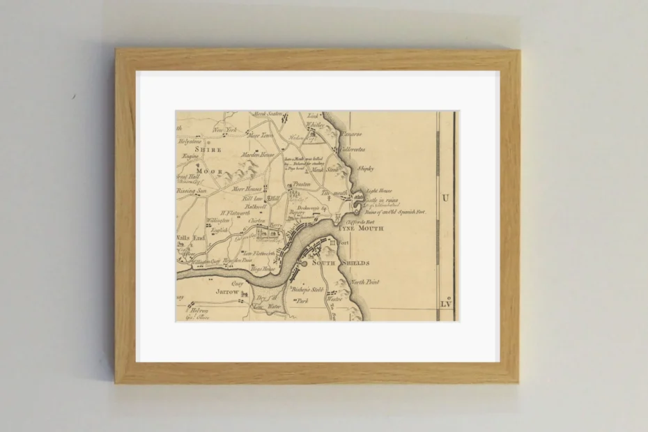
Armstrong’s Map of Northumberland dates from 1769, so it’s a few years older than the Fryer Map featured here. It’s a large-scale, extensive, clear and detailed map drawn by a former army major, Andrew Armstrong, who went into the map making business after retiring.
Along with practically every dwelling meticulously marked, some things we see in this cropped section include:
- The Spanish Battery labelled as ‘Ruins of an Old Spanish Fort’. It had been constructed over 200 years earlier.
- The mill at the village of Milnton in Tynemouth. This stood on or very near the site of the Mariners’ Asylum on Tynemouth Road.
- At Chirton, Edward Collingwood’s estate is prominent. He was a barrister, landowner and cousin of Cuthbert Collingwood of Trafalgar fame. Collingwood built Greenwich Hospital, Dissington Hall in Ponteland and the first dock where Smith’s Dock is today.
- In North Shields, an incipient Dockwray Square is marked. It was a landmark development at the time. Captain Stevenson’s Ropery is shown next to it (hence Stevenson Street today). The roperies were really the seed of North Shields’ economic and geographic expansion.
- Further up the coast, an area somewhere between Tynemouth and Cullercoats is strangely marked as ‘Shipley’. The origin of this name is ‘sheep lea’, but could its inclusion here be an error?
- Brown’s Point between Cullercoats and Whitley is called ‘Panarse‘, indicating salt pans.
Other places:
- New York, named after the colony in North America that became a British possession 100 years prior to this map.
- The Monk’s Stone with an explanation of its provenance.
- Indications of coal working in North Tyneside with an engine located at or near the site of Middle Engine Lane. Engines for pumping water from mines were a fairly new idea at the time. Perhaps this was one of James Watt’s pioneering machines invented in 1765, just four years prior.
- Inns caled the ‘Riseing Sun‘ and the ‘Rose‘ are shown in outlying areas of Wallsend, corresponding to their locations today.
- On the South Shields side, Mill Dam, the Roman Fort, Westoe and Jarrow Slake are shown, as well as a boundary post called ‘Bishop’s Stobb‘ around Laygate.
All of these spots are from a tiny section from the main map of the entire county. The Armstrong Map is an incredibly rigorous work and it’s remarkable that it is so old given how recognisable it is to us today. Yet it still contains enough intriguing places that present a mystery…