By Crasterfarian
The Fort and Its Remains
Benwell fort, or Condercum as it was known to the Romans, sits on the high ground to the west of Newcastle. It was the first fort west of Pons Aelius and it’s thought that the site was redeveloped into a fort very shortly after the Wall was completed, or perhaps just before it was finished.
As you can see on the initial picture, the Vallum goes around the fort and wasn’t built over, as withn other forts added later further along the Wall. The cement may not have been quite dry on the Wall before the order came through: “WHOA HANG ERN LADS, CHANGE OF PLAN, HOWK THAT WAIRL DOON YIV JUST FINISHED, AND STICK A FORT IN THERE”.
Turret 6a is only 80m to the east of the fort, Turret 6b is the other side of the west fort-wall, meaning it was plonked right in the middle of the two. If you drive up there, you’ll see why, it’s a lovely flat spot right on the crown of the hill.
Built as a cavalry fort, its northern third protrudes from the Wall. The north, east and west gates cold be flung open allowing rapid deployment of the feared Ala cavalry to rout any attacks by the locals.
During World War II, Poland was overran by the Wehrmacht. In those days, the term ‘good tank country’ was used. It also applies to the land to the north of the Wall here: sweeping open ground would have meant sure death by a cavalryman’s spatha to anyone attempting to attack the fortifications.

Little remains today, as this area was utterly consumed by the construction of the High Service Reservoir constructed by the Newcastle and Gateshead Water Company, which first shows up on OS maps in 1864.

The reservoir, now covered over, is still in use providing water to the West End of Newcastle. The need for fresh water for an expanding city and the workers’ houses that lay in neat parallel lines from the top of the hill down to river, outstripped the need for historical preservation.
All those houses supplied labour to Lord Armstrong’s factory, which at its height during World War I employed 80,000 people making munitions. My Great-Great-Grandfather being one of them — the draw of work brought them all the way down from Littlehoughton.

During the excavations of the reservoir, very very old coal workings were found, and these have been attributed to the Romans. Romano-Geordie pitmen howking black diamonds from the ground, how things have changed…
The hypocaust from the commandant’s house and a Roman altar were discovered on the site during an excavation in 1937 while a road was put in for the housing estate.

The most amazing discovery of the 1937 excavation was a torc. It was fragmented but it’s one of the only military decorations discovered in the North. It is 150mm in diameter and would have been suspended on the chest with a leather strap. A bit like a horse brass really…
Excavations in the 1920’s also produced several finds including the strongroom along with a number of dedication altars, brooches and a silver spoon. Fancy that, in Benwell folks with silver spoons in their mouths…

If you think the West End is diverse now, consider that many differing cohorts were deployed to the fort and men born in Northern Germany and Spain found themselves shivering in the northern winters. Howay man, can you imagine: born in the Basque region of Spain, your childhood in the sun, then joining up and ending freezing ya ballistas off in a dress and leather sandals? I bet more than a few legionaries questioned their decisions to join up whilst stood on guard in a Northumbrian winter…
A Safe Haven
If you can imagine back then, the portion of very fertile, south facing land that sloped gradually down to the River Tyne, must have been a very safe haven during Roman times. As detailed below, the land would be protected by the Wall to the north, the mighty Tyne to the south and be sandwiched between the Roman Bridge at Newcastle and the ford at Newburn. Newburn was a traditional crossing point of the Tyne going back millennia, as it was the closest fordable point of the river to its mouth. There is also thought to be a fort somewhere under Newburn that protected the crossing there, pre-Wall. All in all, this would be a very safe place to live, prime Romano-British real estate.


One site on Hadrian’s Wall really stands out and I bet most of you have driven past the road end and never noticed it. The Benwell Vallum crossing is a one off: there hasn’t been a walled Vallum crossing discovered anywhere else on the Wall.
It’s almost bridge-like and not dissimilar to the fortified medieval bridge at Warkworth, with a gated entrance constructed in the middle. It stands in the centre of a housing estate, a strange thing to behold in an urban setting. I wonder if the initial plan for the Wall forts was to add these bridged causeways all along the frontier?
Was Condercum a prototype fort? Maybe. It’s very similar to the next big cavalry fort at Cilurnum (Chesters), but that had no need for a Vallum crossing due to the River North Tyne at its south, and the bridge to its east where Hadrian’s Wall crossed the Tyne.
The Temple to Antenociticus
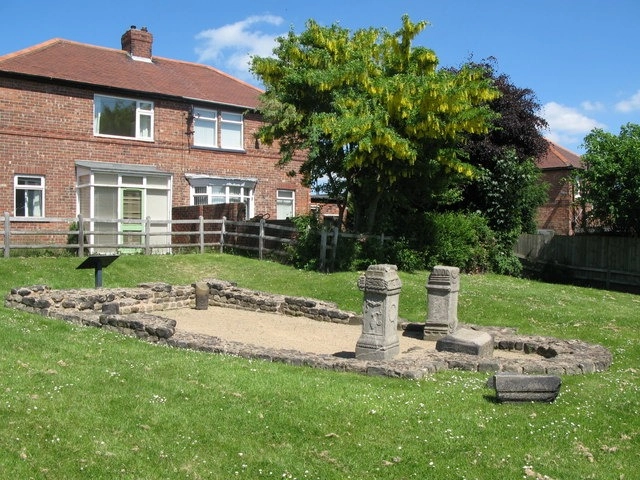
The Vallum crossing point is accompanied, a little further east, by yet another unique Roman site. It’s a temple and it too stands in the middle of the housing estate. It too is unique in Roman Britain, not as a temple, they are everywhere, but unique in to whom it is dedicated: a local Celtic God named Antenociticus.

Three dedication altars were discovered here. These reads, as illustrated in Collingwood Bruce’s book, as:
Deo Anocitico
iudiciis Optimo-
rum Maximorum-
que Imp(eratorum) N(ostrorum) sub Ulp (io)
Marcello co(n)s(ulari) Tine-
ius Longus in p[re-]
fectura equitu[m]
lato clavo exorna-
tus et q(uaestor) d(esignatus)
Which Translates as
To the god Anociticus
Tineius Longus (set this up) having,
while prefect of cavalry,
been adorned with the (senatorial) broad stripe and designated quaestor by the decrees of our best and greatest Emperors,
under Ulpius Marcellus, consular governor.

The head of a statue was also discovered in 1862 complete with a torc around his neck. The hair curls forward to represent two horns. A recent find at Binchester (Vinovia) Fort to the south of here is also thought to be Antenociticus but this has not been conclusively proven. Other smaller parts of the statue were found including legs meaning that it stood at a full man’s height when first made.
The temple is dated to around AD 180 as dedication coins were found under the altars.
The finds from this site reside in the Hancock…ooops, sorry, I mean the Great North Museum in the city centre. It’s free to enter and well worth a visit if you are in the area (If you are a certain age the Great North Museum will always be called the Hancock).
Conclusion

Antenociticus and Cocidius were distinctive deities worshipped along the northern frontier of Roman Britain, each reflecting the blend of native and Roman religious practices.
- Antenociticus was a localised god primarily known from the Roman fort at Benwell (Condercum). His cult seems unique to this area, suggesting a deep connection between the soldiers stationed there and the local spiritual landscape.
- Cocidius, by contrast, was a more widely venerated god associated with hunting, warfare and natural forces, with strong ties to sites like Bewcastle (Fanum Cocidi). His popularity across multiple forts highlights his importance in the frontier region.
The Romans, aware of the power and significance of local deities, often incorporated such gods into their own religious framework to maintain peace with the locals and avoid divine wrath. This practice reflects Roman superstition and pragmatism: honouring indigenous gods helped secure local favour and protect the military presence in volatile borderlands. It’s ironic that despite their obvious military superiority, the Romans wanted to integrate with local gods to avoid their wrath!
We never know what is beneath our feet, especially in the North of England: an area of land fought over for millennia. Always look and think where you walk, about what might have happened beneath the very spot you stand. Hadrian or Severus himself may have stood in that very spot while he surveyed the land.
I wonder if they felt like Alexander and the tales of old they would have been familiar with (and Hans Gruber’s bastardised version in the film ‘Die Hard’):
“When Alexander saw the breadth of his domain, he wept for there were no more worlds to conquer.”
Whey guess what hinnies, it didn’t last. You conquered nowt laang torm, its airl wors again, and ya wairl is a tourist attraction, your mark on this land meant nothing.
Or did it…?

This image was taken whilst on an EasyJet flight out of Newcastle one November morning. You can see the line of streetlights of the route taken by Hadrian’s Wall blazing its trail westwards. Look to the right of centre, you can see where the road comes up from Pons Aelius. This modern road, in its inception, was the demise of the Wall and its associated features.
In 1745 General Wade commissioned the construction of a link road between Newcastle and Carlisle to allow the movement of troops and cannons between the two cities should there be another Jacobite rebellion….
Will the fighting never cease……
With Love from the Crasterfarian XX
Excellent piece on a patch of ground very near to where I grew up. Learnt a few new facts, too – thank you.