By The Crasterfarian
When people picture a Roman fort, they often imagine the neat, playing-card rectangle that appears in every textbook. It’s a shape built on order, discipline and the Roman way of protecting their power across the Empire.
Yet in the hills and valleys of northern Britain, the Romans could not always force the land to bend to their design.
At Epiacum (Whitley Castle) and Fanum Cocidi (Bewcastle), unusual fort shapes were employed to suit the topography and existing features.
Then at Burnswark, in the Borders, we see evidence of the army’s willingness to adapt, improvise and even experiment. Was this site the ‘Otterburn Ranges’ of the day, or was it a stubborn tribal citadel that refused to bow to the legions?
Were some of these sites prototype forts, concepts for change tried out by the legions in the farthest flung outposts of the Empire? An attempt to buck the norm, create a trend — or simply a case of the lie of the land dictating the plan?
That being the case, and as discussed in a previous article, why was Vercovicium (Housesteads) built on a strange angle when it could have been laid out in the Knag Burn Gap, or further west where the land is flatter?
Epiacum — The Trapezium Fortress
Epiacum (modern Whitley Castle) sits high above the River South Tyne. Instead of a rectangle, the fort takes on a trapezium shape, its walls skewed to follow the natural ridge.
Building here was about more than just following the norm; it was about putting a stamp on the landscape regardless of the topography.
The steep scarps on three sides gave natural defence, while the trapezoid layout allowed the Romans to enclose the summit without the back-breaking labour of cutting terraces into the hillside.
The fort’s multiple ramparts and annexes suggest it was more than just a standard garrison: a centre of control, perhaps for nearby lead and silver mining, and a stronghold to dominate the upland route and defend their silver as it traversed the Maiden Way road.
The route of the road up the South Tyne Valley can be seen on the LiDAR image below as it skirts the eastern side of the fort, then heads north to join the Stanegate road at Magnis, along to Banna, and up the branch of the Maiden Way as it heads for Fanum Cocidi, the next anomaly on this odyssey into the unusual.

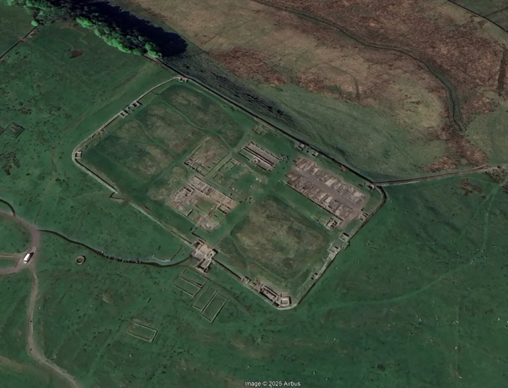
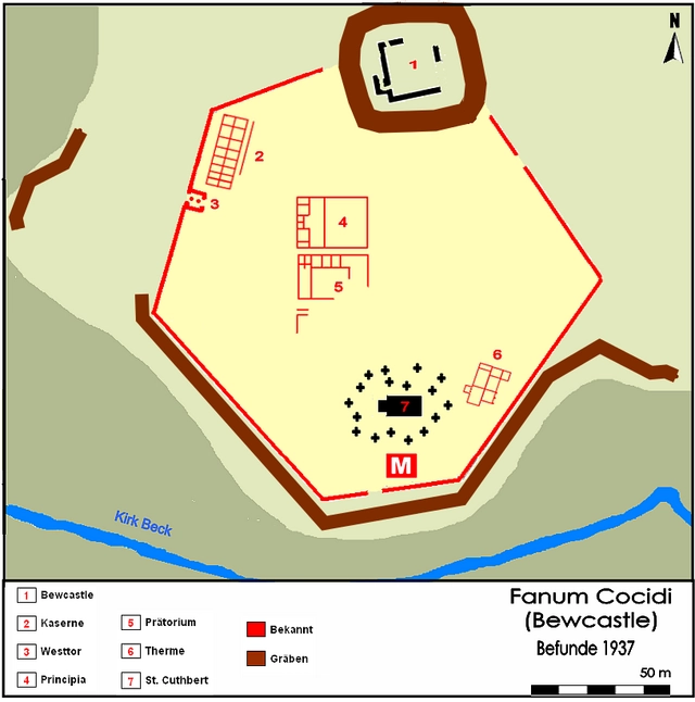
Fanum Cocidi — The Hexagon Watchtower
North-west of Hadrian’s Wall, Fanum Cocidi (Bewcastle) takes an even stranger form: a hexagon, irregular and lopsided, its six sides pressed against the rising ground.
Built within the boundaries of an existing Iron Age hillfort, the fort follows faithfully the rough shape of the earlier ramparts, creating a geometric enclosure within ancient turf.
From here, the garrison had commanding views across the Irthing Valley, and easy communication along the Maiden Way back to the Wall. A remote outpost in hostile territory, was this shape more appropriate to defend against raids in this area?
The hexagonal plan was no idle flourish. By using six angles instead of four, the walls could hug the contours closely, eliminating blind spots and awkward corners.
The fort also bears witness to the Roman habit of blending their occupation with local belief. Its name means “the shrine of Cocidius,” a native northern god of hunting and war, widely venerated across Cumbria and Northumberland.
Dedications to Cocidius appear at other Wall sites, showing how Roman soldiers respected, or at least acknowledged, the local deity. Naming the fort after him was both a mark of cultural adaptation and a way of binding garrison and landscape together.
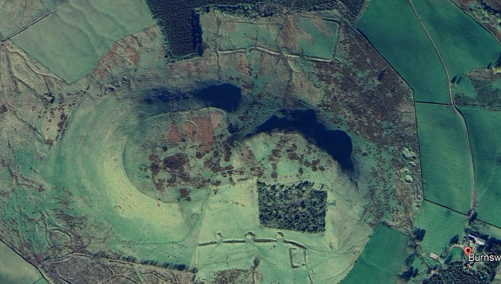
Burnswark — The Roman Firing Range
Travel further west and another anomaly emerges, Burnswark Hill. Here we do not find a permanent fort but a battlefield.
A native hillfort crowns the summit, while two Roman camps face it from either side.
Neither of these camps is a standard Roman playing-card outline. Both are irregular, shaped to the slope and to the role they were meant to play.
The southern camp in particular shows unusual projecting platforms, almost turret-like, interpreted as strongpoints for ballistae (catapults) and artillery.
Excavations have uncovered thousands of lead sling-bullets, many drilled with holes to whistle in flight, along with heavy stone shot. Was it a real assault, a brutal demonstration of power? Or was it something else, a live-fire training ground for the legions, a place to practise storming a hillfort under battle conditions?
The latter seems likely, and it finds a striking parallel in the Northumbrian landscape centuries later.
During the First World War, trenches were dug above Rothbury so the Northumberland Fusiliers could practise the skill of digging in and defending.
At Otterburn, the Royal Engineers constructed trenches not to occupy, but to experiment with methods of destroying them more effectively.
In much the same way, Burnswark may have served a dual purpose: soldiers learning how to assault a fortified hilltop, while commanders and engineers refined artillery placements, tested siege tactics and even trialled psychological weapons like the eerie whistling sling-bullets.
Despite the technology of modern warfare, old tactics, laid down millennia ago, are still pertinent.
Pragmatism, Not Prototypes
Were Epiacum and Fanum Cocidi “prototypes” for new fort designs?
Not quite. Across the Empire, the rectangular fort remained the rule. However, in Britain’s uplands, the land dictated compromises.
The trapezium at Epiacum and the hexagon at Fanum show local ingenuity. Burnswark, meanwhile, shows how the Romans trained and tested their troops in Britain’s conditions, using irregular camps and turreted artillery platforms to make the battlefield itself a proving ground.
Conclusion
The forts of Epiacum and Fanum Cocidi, together with the battlefield/training ground (we may never know) at Burnswark, remind us that Roman order was never as rigid as it first appears.
The legions carried with them traditions and a love of uniformity that was driven by discipline, yet when the landscape resisted the Roman template, they adapted.
Along Hadrian’s Wall, however, this flexibility was curiously absent. Milecastles were built to standard designs, often with north-facing gates placed high on the Whin Sill where no road could ever reach. These were soon bricked up, obedience to the plan, yet disobedience to common sense, perhaps a quiet compromise to avoid the displeasure of some Roman architect.
There is the odd exception, as in the case of Halton Chesters fort on the Wall, near the Port Gate where Dere Street crossed the Wall line. Here an annex was constructed during the Wall’s refurbishment under the reign of Septimius Severus, in his attempt to tame the Caledonii. Unusually, this annex was built to one side, producing a curiously shaped fort. We know the reason for this was the long-established vicus south of the fort, which prevented expansion there.
Elsewhere though, the army bent the rules. They raised trapezoidal forts on ridges, hexagonal enclosures on hillsides, and irregular artillery camps to dominate Iron Age strongholds.
In the North, Rome’s surveyors and engineers showed themselves not just as builders but as problem-solvers, learning, like the soldiers at Otterburn and Rothbury, my great uncle being one of them, how to adapt to a situation and utilise it to the best strategic outcome.
With love from The Crasterfarian XX
Oh no not another Metro extension! Fabulous work as usual, your imagining of all this takes us there in both place , and more importantly, time