By Crasterfarian
The more I read and write about history, the more I understand that what we are left with in today’s landscape are simply ghosts of former features and faint hints in the land.
Common sense is a huge factor in understanding the way people thought back then. They were no different to us: they had the same issues, the same worries, and usually arrived at the same solutions to problems.
Human beings are, by their very existence, lazy, and given the topography of Northumberland, the easy route would almost always have been the preference.
The quickest way between two points is a straight line. If the ancient inhabitants of this country hadn’t already realised that, then the Romans certainly left enough clues in the form of their roads. Many of those roads are still used today.
I can understand wandering routes and diversions where the land is difficult, but on open, flat ground why would you do anything else? The coastal fringes of our green and pleasant land have always provided relatively simple routes from place to place. Yes, rivers are a huge obstacle, but they were fordable at estuaries in most cases.
Remember, the river estuaries and ports we see today have been heavily modified by the hand of man since the Industrial Revolution to accommodate deeper and larger shipping.
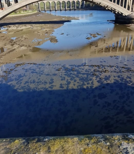
Back in the so‑called Dark Ages, most rivers had a fordable point, normally inland (such as at Newburn or Ubbanford) or right at the estuary. The Devil’s Causeway itself heads diagonally across Northumberland, aiming for the estuary of the Tweed, which was fordable at that point.
The image below shows the forded crossing point of the Tweed into Berwick, which in my opinion marks the location where a Roman road crossed into the north and the Votadini tribal heartland, safe from the reach of the legions beyond the mighty Tueda (Tweed).
The Line That Joins Them All
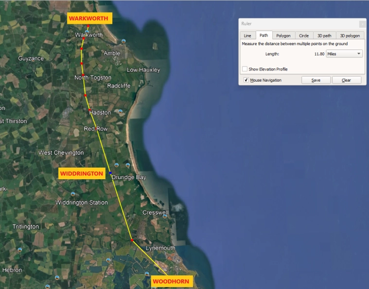
My theories regarding a road between Woodhorn and Warkworth have been building for some time, and the more I have dug into this, the more convinced I have become that such a road must have existed.
All of this has come simply from following the clues left to us in the land itself: maps, placenames, and archaeological finds.
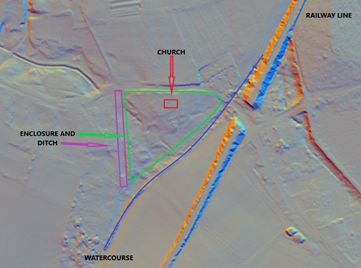
The Church of St Mary at Woodhorn has always intrigued me. I lived a stone’s throw from it for several years and often wandered down, not out of any religious pull, but from simple archaeological curiosity.
It sits quietly, seemingly in the middle of nowhere, yet it feels like a place that has been important for far longer than the standing building suggests.
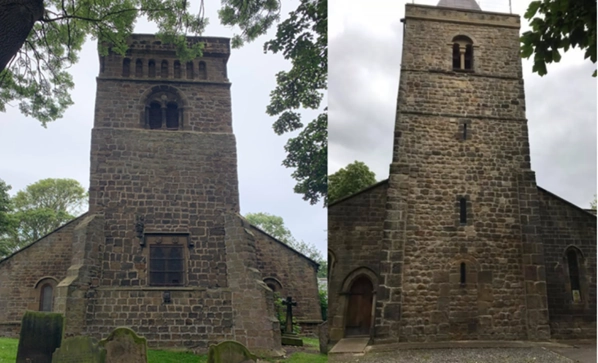
What sharpened that curiosity was comparing Woodhorn with the church at Newburn, where I have sat many times eating my lunch, as our office is nearby.
At Newburn, the Roman origin of much of the stonework is obvious. The masonry is heavy, squared, and confident, very different from later medieval rubble.
It looks Roman because it is Roman, reused stone taken from nearby Hadrian’s Wall and incorporated into a later Christian church.
When you stand at Woodhorn and look closely at parts of the stonework there, you get the same feeling. It is not that the church itself is Roman, but that Roman stone appears to have been reused.
The proportions, the stonework, the overall feel of it all suggest Roman stone, recycled into a later church building.
However, that is not the whole story at Woodhorn. The site it sits in feels ancient — non‑linear, almost pagan. I can already hear the objections: a pagan site reused by later Christians? How very dare you. But that is precisely what happened.
Pagan sites were often destroyed or repurposed by early Christians attempting to purge the land of the old gods.
Places like the Mithraic temple at Brocolitia were deliberately demolished and filled in thankfully preserving the original altars in situ.
Places like the reused Mithraea at Hartburn Glebe, the Hermitage at Warkworth, and many other caves converted into later church buildings and rebranded as Christian sites.
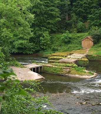
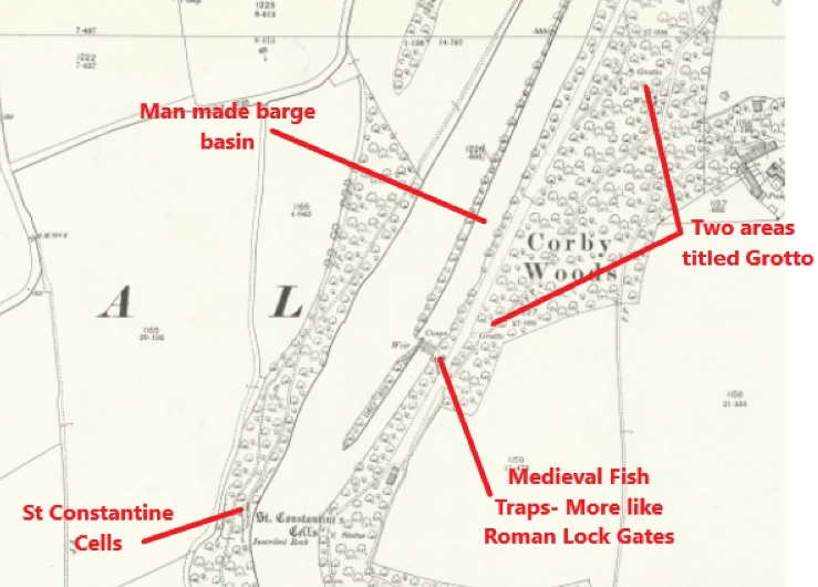
I need offer no more evidence than the so‑called ‘monastery fish traps’ at Wetheral Abbey in Cumbria.
Anyone who believes those fabulously well‑built stone weirs and water races were constructed merely to catch fish by a handful of monks needs to go and have their heads examined.
The site there is also surrounded by ‘St Constantine’s Cells’ and ‘Grottos’. Every single one will be a reused Roman site, converted for the service of the one true God.
Pangus man, ya off again
Aye, I know I keep banging on about this, but I am passionate about it.
I am convinced that the north of England was more widely used by the Romans, not merely as a military boundary, but as a place where people and families lived, not some vast military hinterland devoid of life beyond the discipline of the legions.
Soldiers who were officially forbidden to marry and those that were became divorced on enlistment will still have had ‘local’ families living in the vici around these sites.
These men and their families needed sustenance for their bodies in the form of food and prosperity, but they also needed sustenance for their souls and inner peace in the form of their gods, just as people still look to deities today for absolution, comfort, or an afterlife.
Anyway, back to Woodhorn…
This all matters because Roman stone rarely travels far without reason.
Its presence usually points to nearby Roman infrastructure, now lost to strip mining, robbed out, or buried beneath later activity. That possibility fits neatly with the documentary record.
In 737, Ceolwulf of Northumbria granted land at a place recorded as Wudecestre to the monks of Lindisfarne.
Wudecestre, sometimes rendered as Woodchester, has long been associated by some scholars with the area around modern Woodhorn.
The ‘cestre’ element derives from the Latin castrum, meaning a fort or military site, and its survival in an early medieval document strongly suggests a possible Roman presence in the landscape, even if the physical remains had already begun to vanish.
The geography reinforces this interpretation.
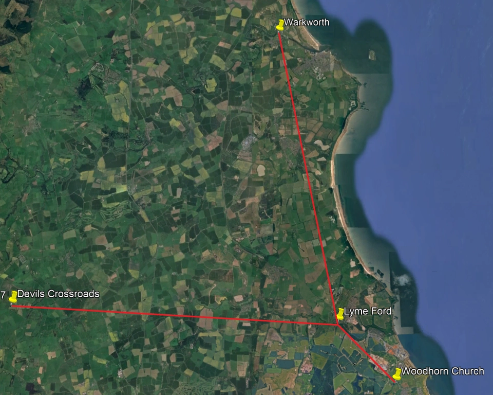
Woodhorn lies beside a natural movement corridor along the north side of the Wansbeck. The stretch of land between here and the River Coquet is largely uninterrupted by major watercourses, other than the River Lyne.
I have long suspected the existence of a Roman road running to Ellington and the Lyne ford, before continuing through what is now Widdrington and on towards Warkworth and the coast beyond.
At the Lyne Burn ford, it is plausible that a branch ran west to join the Devil’s Causeway network at a crossroads south‑west of Longhorsley.
There may also have been a road west from Woodhorn itself, crossing the Wansbeck at Stakeford and heading south towards the eastern end of Hadrian’s Wall.
This is where Raymond Selkirk’s work becomes particularly relevant.
In his studies of Roman movement in Northumberland, Selkirk argued that the Devil’s Causeway was not a single rigid line, but part of a wider network, with branches and junctions responding to terrain, river crossings, and coastal access.
He identified what he referred to as a Devil’s Corner or Devil’s Crossroads along the line of the Causeway, a place where routes appear to diverge rather than continue cleanly north or south.
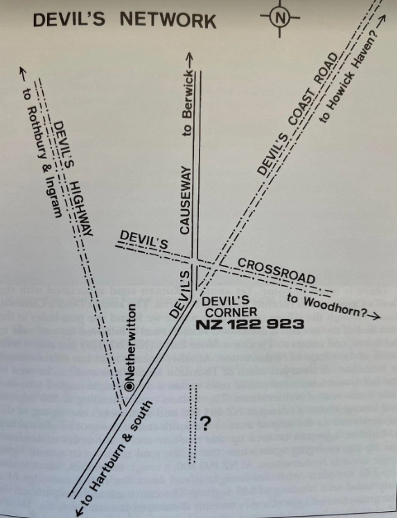
He believed two branches ran eastwards from this crossroads towards the coast, one to the NE and Howick, and one due East to Woodhorn.
Selkirk’s ideas were often controversial, and he was vilified and shunned by more conventional archaeologists and historians, but his theories were rooted in careful observation of how landscapes behave rather than blind adherence to accepted maps.
Roads do not exist in isolation, they don’t go to nowhere, not when you consider the physical work of building them with no mechanical means.
They exist to connect places that matter.
A road running from the Devil’s Causeway towards Woodhorn, then branching north to Widdrington and Warkworth at Ellington, and south to Woodhorn, makes sense if the coast was being supplied, monitored by the legions, and controlled for taxes in the form of grain.
Small boats could be beached to accept grain tributes, which were then transferred to larger vessels of the Classis Britannica (tghe Roman fleet of Britain).
It also helps explain why Woodhorn sits where it does, and why it carries both documentary hints and physical whispers of something older beneath the medieval church.
The Source of the Name
The name ‘Devil’ itself deserves careful handling.
Across Northumberland and beyond, Devil placenames are frequently attached to ancient roads, earthworks, stones, and crossings.
In most cases they are not evidence of devil worship, but of later Christian unease with places that were already old, powerful, or poorly understood. What could not be easily explained was recast as uncanny.
In some instances, these places do overlap with earlier pagan ritual landscapes, but the word Devil more often marks memory and fear than theology.
The Devil’s Causeway, a road of the Devil, a road to the pagan, a road to pre‑Christian fears and sites of dark ritual.
Seen in this light, Woodhorn ceases to be an isolated curiosity and instead becomes part of a wider, layered landscape.
Roman infrastructure fades into Anglo-Saxon trackways, early Christian foundations anchor themselves beside inherited routes, and later medieval buildings consolidate control over the same ground.
Like Newburn, Woodhorn reads as a place where the past was never erased, only repurposed: Roman stone reused, Roman routes remembered, free building stone left behind, and opportunity taken to rebuild, reshape, and rebrand the old into the new.
If we read the landscape properly, Woodhorn sits not at the edge of history, but within its flow.
On a branch road off the Devil’s Causeway, linked to coast and inland alike, it becomes one more thread in a long continuity that runs from Roman Northumbria through Bernicia. These threads of roads and earlier peoples formed the early bones upon which the Golden Age of the Northumbrian Kingdom was built and hard fought for.
With love, The Crasterfarian xx
P.S. Much of my inspiration comes from my Mammy Joan dragging me round places as a bairn, and visionaries like Raymond Selkirk, who saw beyond what he was told, and attempted to create a plausible map of our land. Combined with the writing of Matthew Harffy and his Bernician Chronicles, this has opened a door in my mind, encouraging me to look further and deeper into what we walk over and pass every day.