By Crasterfarian
As a born and bred Crasterfarian, I’ve always wondered about the history of where I was brought up. The very fabric of the village and its surrounding landscape has inspired a sense of wonder in me since I was small, and it’s possibly why I’m now so deeply into history, especially local history.
The more recent story is obvious, starting with the harbour and fishing industry, quarrying, and the WW2 heritage of the POW camp and Chain Home Low radar station, then along to the 13th-century castle. But my thoughts stretch further back, beyond the Romans, to the true original inhabitants of this coast.
As nomadic tribes settled and put down roots, you can see why they chose this place. Like today’s holidaymakers, they were drawn by its beauty, but for them it was more than scenery. It offered pasture for grazing, fresh water, and a sea teeming with fish. It was the perfect place to build your hill fort and roundhouses.
I’ve long imagined settlements all along this stretch of coast, people with nothing but their guile and wits to keep them alive. People who lived as naturally as the Aboriginal peoples of Australia, at one with the earth, leaving little behind but the faintest hints of their presence in the form of earthworks and stone circles.
Let’s start at the north end and head south. As I’ve written before about Nova Scotia, this coastline is steeped in maritime and medieval history, but what came before?
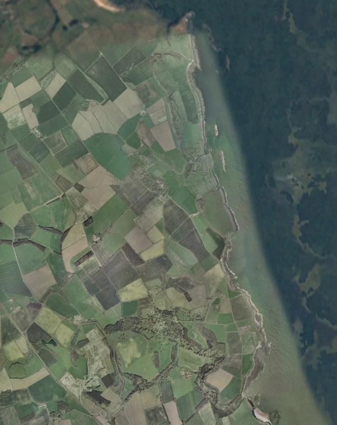
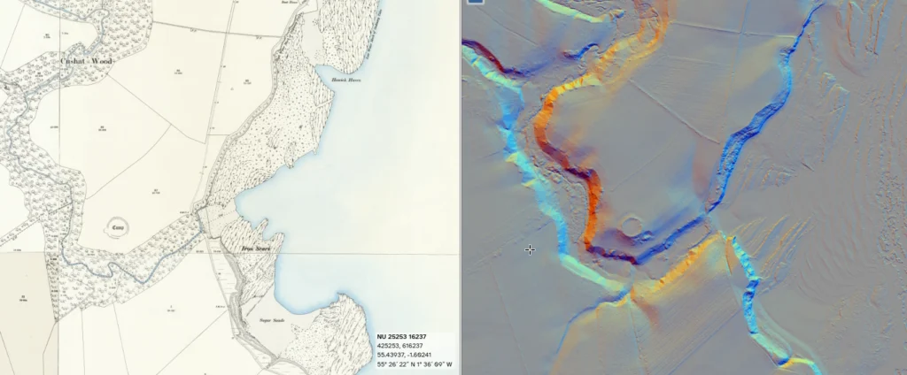
The black basalt ridge of the Whin Sill cuts through Northumberland’s coast like a blade, and nowhere does it shape the land more dramatically than around Craster. Long before Dunstanburgh Castle rose on its headland, this was already a landscape marked by human design.
Beneath the Castle lie signs of continuity. The great basalt platform doesn’t align perfectly with its medieval curtain walls, and traces of older ditches and embankments hint at a much earlier strongpoint — perhaps Iron Age or even Roman. The medieval builders simply claimed what had already been chosen for its commanding strength, on the hardest rock of the coast overlooking havens that had served generations before them.
From the Neolithic through the Romano-British period, people repeatedly turned to the Whin for its height, its strength, and its shelter. LiDAR imagery reveals that what looks wild and natural often bears the imprint of ancient use.
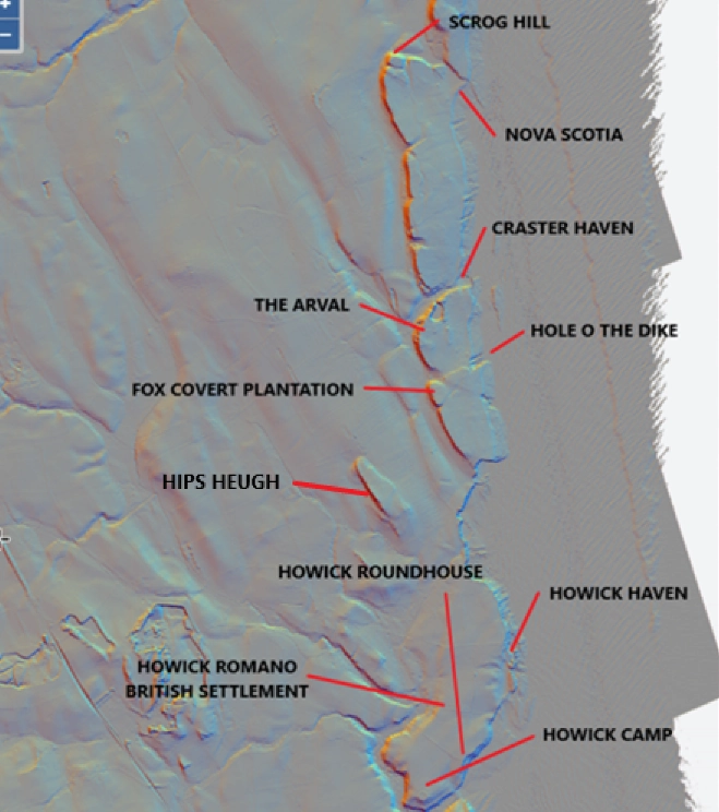
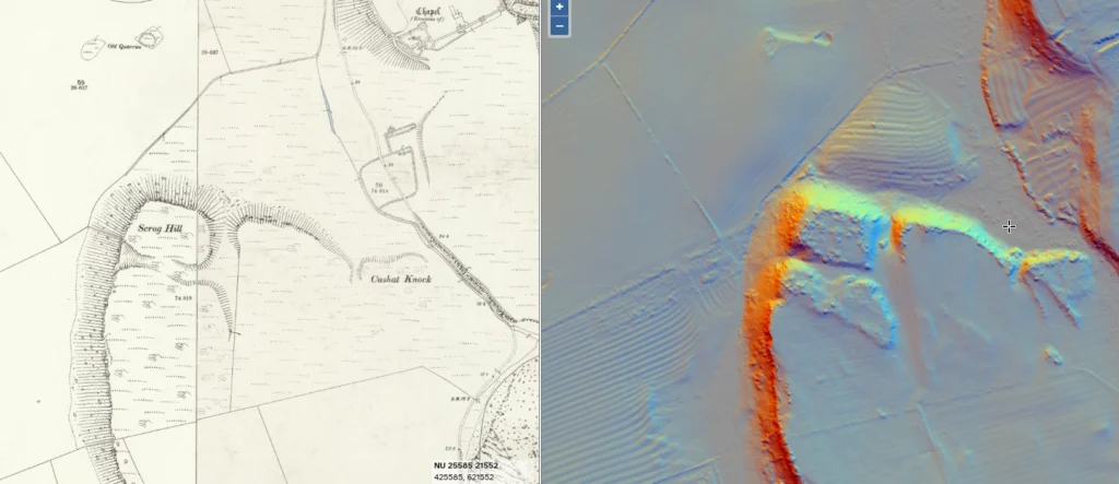
Scrog Hill and Nova Scotia
Scrogg Hill shows a striking man-made feature. Below it, the sheltered inlet known as Nova Scotia would have offered safe anchorage for small boats long before medieval harbour works appeared.
The hill itself looks altered by human hands, a trench or ditch cut across the Whin to create a defensible area to the north. It may once have been crowned with a timber palisade, long since rotted away in its exposed position.
It’s easy to picture coracles or hide-covered craft drawn up on the shingle, used by communities who fished or traded along this rugged shore.
The Arval and Craster Haven
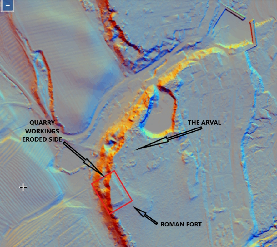
Above Craster, the so-called “hill fort” at The Arval may be the most telling of all.
Its shape breaks from the flowing curves typical of Bronze or Iron Age enclosures. It’s distinctly rectangular — deliberate, almost Roman.
Quarrying on the northeast side has removed part of its outline, but enough remains to lay a rectangle cleanly over the surviving earthworks. Early stone extraction from Scotchman’s Quarry likely erased the rest of its western side.
The Arval’s vantage over both coast and countryside would have made it an ideal signal post or supply depot, guarding the small haven below and watching the sea route north to Dunstanburgh and south to Howick. The surviving plan still matches the square precision favoured by Roman engineers.
Beneath the modern South Pier at Craster lies a natural rock promontory, now hidden by the pier itself. This would have sheltered the earliest Crasterfarians and their fishing boats long before the harbour was commercialised for exporting Whinstone sets and roadstone to late Victorian and Edwardian England.
The inlet, at the eastern end of a fault line that splits the Whin Sill in two, offered safe mooring for small boats and a natural burn providing fresh water to clean fish and quench thirsts.
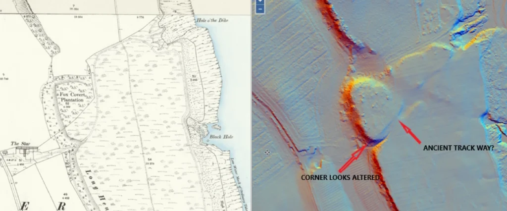
Fox Covert Plantation
The fault line running from Fox Covert toward the Hole o’ the Dike looks more than geological — it reads like a purposeful descent, a path to the shore worn into the land by ancient Northumbrians. It appears to form a man-made enclosure, perhaps very early, possibly Neolithic in origin, which might explain the lack of finds (not that it’s ever been investigated).
The Whin itself, where the fault begins near Scar Farm, looks shaped to form a defensible rampart, perhaps once topped with a palisade. The cut to the southwest corner doesn’t look natural, more like something crafted to create a steep barrier.
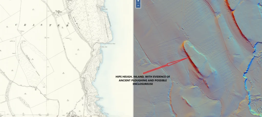
Hips Heugh
Just inland, Hips Heugh forms a second tier of the Whin Sill, rising like a shadow ridge behind the main coastal line. Its position offers shelter from sea winds yet still commands a broad view across the coastal plain. LiDAR shows hints of terracing or platforms along its crest, suggesting occupation or use at some stage.
The summit hosts an old Ordnance Survey trig point — the highest ground in the area and an advantage in troubled times. Whether for stock, watch, or ritual, Hips Heugh may have been part of the same long sequence of land use, the inland counterpart to the fortified and harbour-facing sites below.
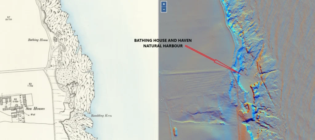
The Bathing House and Howick Haven
Further south, near the Bathing House at Howick, another haven fits the pattern. The cove below is sheltered, a natural harbour facing northeast, with a long shallow beach that would have allowed craft to be pulled safely above the tide line.
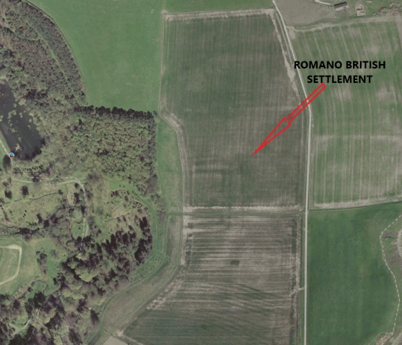
Romano British Settlement
There is also a Romano-British settlement in the near vicinity detailed below as crop marks, this was only discovered in the 1980’s and has yet to be excavated
Howick Roundhouse
North of the camp, on a gentle rise overlooking the sea, lie the traces of a stone-built roundhouse, likely part of a small Romano-British farmstead that followed the Iron Age fort’s abandonment. Its low ring of stones still catches the evening sun, marking where turf walls and a thatched roof once stood. From here, families watched their stock graze and kept an eye on the sea below, living between two worlds — the fading age of hillforts and the slow reach of Rome along the Northumbrian coast.
Howick Iron Age Enclosure
Just inland from the burn lies Howick Camp, a weathered Iron Age enclosure crouched above the banks of the Howick Burn. Its banks and ditches still trace the outline of a once-defended hillfort.
The site commands a wide sweep of land and sea, linking naturally with the line of coastal strongholds from Craster to Beadnell. Its builders used the Whin Sill’s natural rise to the north and dug deep on the softer southern slope, enclosing timber roundhouses that sheltered a small farming community. Though long ploughed and eroded, the old earthwork still holds the ghost of a people who farmed, fished, and watched the horizon for sails, living between land and sea on that wild Northumbrian edge.
Vessels of the Time
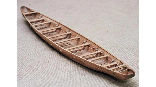
We’ve all seen the cobles used by East Coast fishermen — small, shallow-drafted, high-prowed boats perfect for inshore fishing. The ancients likely used much the same.
The sea provided a constant harvest of fish and shellfish, and ancient builders were more capable than we sometimes credit. Across Britain, remarkable finds show how early seafarers built sturdy boats long before the Roman Classis Britannica ever sailed here.
- Dover Bronze Age Boat (c.1550 BC): Oak planks stitched together with yew withies, sealed with moss and beeswax. It’s the world’s oldest known seagoing plank-built boat, about 9 metres long, capable of coastal and cross-Channel travel.
- Ferriby Boats (Humber estuary, c.2000–1800 BC): Stitched-plank craft, crewed by 4–8 paddlers, suited to estuaries and inshore seas, perhaps trading metal and salt along the coast.
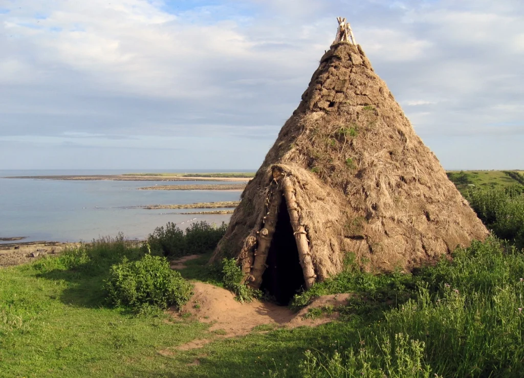
- Coracles and hide boats: Round or oval willow frames covered in animal hide, perfect for rivers, inlets, and short coastal hops between places like Craster and Howick.
- Dugout canoes: Hollowed from single tree trunks, used well into the Iron Age for calmer waters.
- Iron Age plank boats: Later, pegged and clenched planks gave rise to true shipbuilding, some mounting small square sails of woven wool or linen.
Conclusion
Why here? To me, as a layman, it seems obvious. Common sense. This coast had everything early settlers needed. There was food almost year-round, safe landings for boats, and high ground for defence.
Taken together, the Whin Sill around Craster tells a story of endurance and adaptation. From prehistoric fishermen to Roman watchmen to medieval lords, each generation found purpose in the same spine of rock — a geological backbone that guided where people lived, worked, and defended their coast for thousands of years.
These weren’t isolated sites but parts of a broader network, using the Whin Sill as both rampart and routeway. They traded and supported one another through hard times, a true community — much like the one I grew up in, where no matter how poor you felt, you always got by.
I never had a penny in my pocket, but I was never hungry or lonely.
With love from the Crasterfarian XX
An excellent article, Peter; informative, researched and eminently readable. I’m glad that someone else scrutinises the landscape to find evidence of past settlements and communities. I have read several of your articles and you have a definite talent and I suspect there is a book in there somewhere.
I look forward to checking out some of the sites I have not investigated yet.
Cheers Ed, I might sort so thing out when I retire and get it into print!
Thank you Peter I’ve really enjoyed reading this article, written with love and passion about your home.
I spend my spare time wandering about with a camera taking shots of anything that catches my eye, then learning whatever I can about the subjects taken.
Your knowledge has helped be before, thank you once more.