A Theory by The Crasterfarian and Anthony Simm
Background
The River Coquet is absent from conventional accounts of Roman military infrastructure in Northumberland.
Yet when archaeological evidence is assembled, inscriptions, historical finds, placenames, landscape features, antiquarian hypotheses, combined with what would make common sense, a coherent picture emerges.
Let us also not forget the name Coquet is thought to derive from the god Cocidius, a local pagan deity adopted by the Romans, so much so, Bewcastle fort was named Fannum Cocidi.
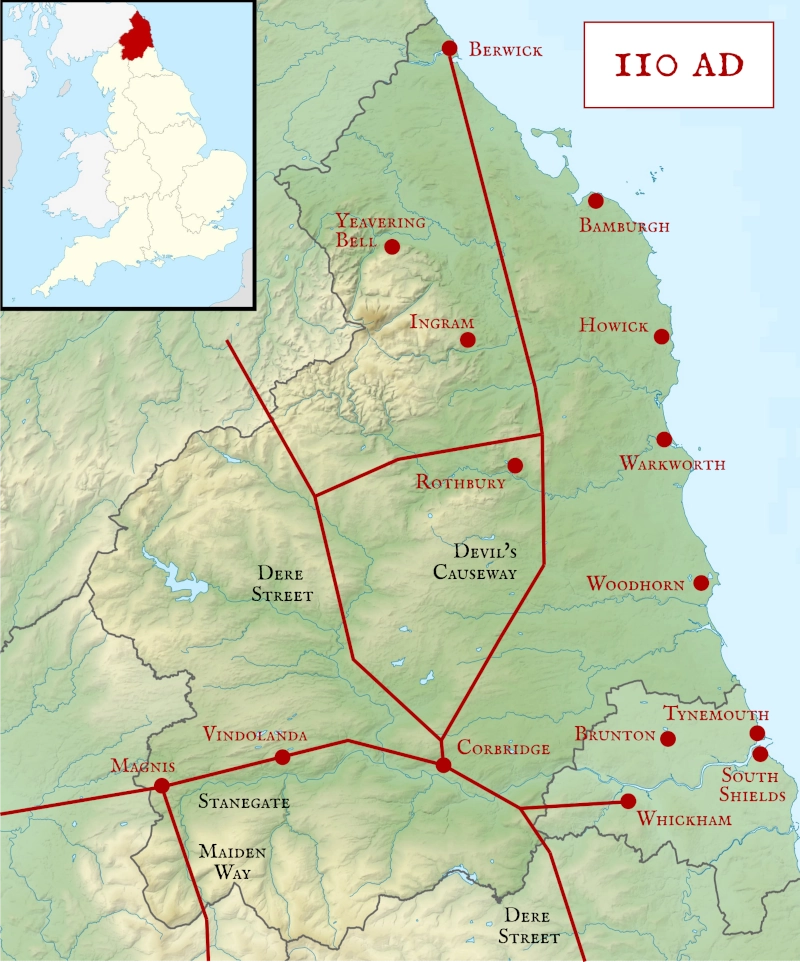
The Coquet Valley may have formed a structured Roman supply corridor, with locations at Amble, Warkworth, Coquet Island, Guyzance, Longframlington, Brinkburn, and Weldon Bridge, linking the coast to the Devil’s Causeway, Northumbria’s arterial Roman highway.
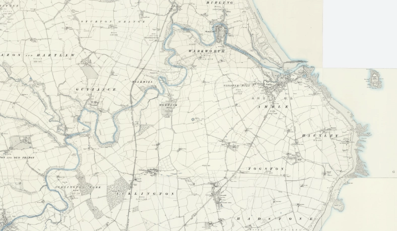
Gloster Hill: Roman Altar and Parade Ground
In 1856 a Roman altar was uncovered on Gloster Hill above Amble. Its dedication to the Goddesses of the Parade Ground (Deae Campestres) implies the presence of cavalry drilling on a campus, a flat, open space for training men and horses. The site commands the estuary and its approaches.
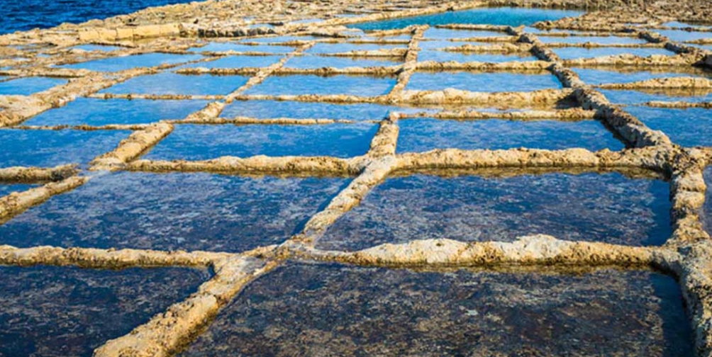
It’s medieval name, Gloucester Hill, echoes Glevum — Roman Gloucester, meaning ‘bright fort’, where ceaster derives from Latin castra (camp). The ‘bright’ element finds a local parallel: the Coquet estuary was a centre of salt production, documented from the 12th century. Based on continuation of use, this could hark back to Roman times where salt was highly prized, even being used to pay the legionaries. The glare of salt pans reflecting on water and marshland may have given the hill its ‘bright camp’ association, preserving Roman presence in name and memory.
Detailed in the image below, we can see historical salt pans in the Mediterranean that have their origin in Roman times.
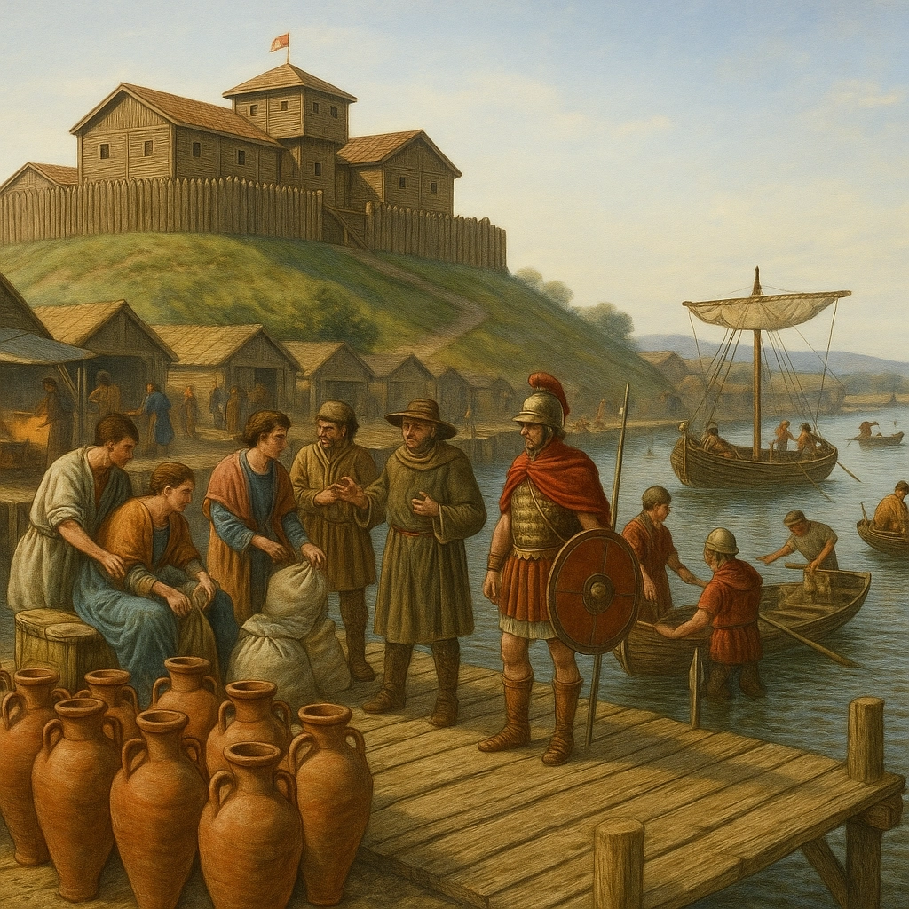
Warkworth: Fort and Port
The defensible neck where Warkworth Castle now stands almost demands fortification. This easily defendable isthmus will not have been missed by the Roman planners and a turf-and-timber fortlet here would be consistent with Roman frontier practice.
The later Norman castle was built for that very same reason, to control traffic north over the bridge at Warkworth. Beneath this neck, the river loop forms a natural harbour.
Antiquarians have long postulated a Roman port or quay at Warkworth. Timber jetties could easily have serviced river traffic and coastal vessels, creating a combined fort-and-port complex: garrison above, harbour below.

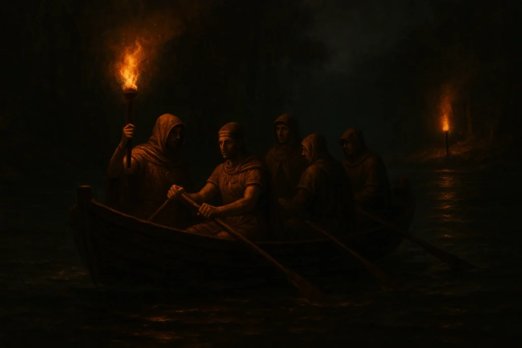
Across the river lies the Hermitage cave, known for its medieval chapel but strikingly grotto-like.
Mithraic shrines (Mithraea) elsewhere in Britain were often subterranean or cave-like — Carrawburgh being the prime example of an attempt to build a cave-like structure.
It is not impossible that the Hermitage perpetuates a Roman cult site overwritten by later Christian use, exactly like the Grotto at Hartburn, on the Hart River, a tributary of the Wansbeck. The Grotto there was a Roman Mithraic temple sat directly on the Devils Causeway.
The site here, north of the camp, would have been perfect. Imagine the faithful leaving the fort under cover of night, boarding a small tender or rope-drawn ferry to cross the black waters. The river lies silent but for the creak of oars and the ripple of the current, their passage lit only by a single torch on the boat. Ahead, on the far bank, a solitary beacon burns, guiding them towards the hidden mithraeum and its shadowed rites.
For those who made the crossing, it must have seemed a moment touched with magic, a rite of passage from the mundane world to the sacred. Moving from south to north, from light into darkness, the journey carried them as if across the Styx itself, into an otherworld where Mithras waited in the cavern’s gloom.
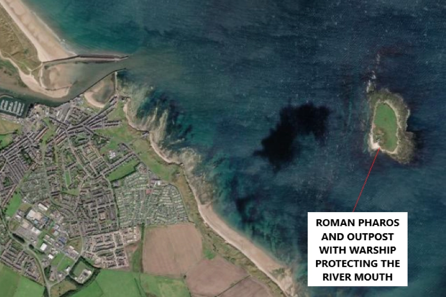
Coquet Island: Offshore Outpost
The Romans made systematic use of small offshore islands for signalling, shrines and observation posts. Coquet Island, a short distance from Amble harbour, is ideally placed for a signal station or beacon. Its position controls north-south sea lanes and complements the estuary port. Even a simple timber tower and small contingent of the Classis Britannica (the naval fleet) would have extended the Roman reach up the coast.
The southwest corner of the island is the most sheltered and would have provided a relatively safe anchorage and landing point even on the most tumultuous days that we know the North sea can produce.
This area is perhaps the most plausible location for a Roman pharos and a small naval barracks, with a warship either beached or moored on the sandy promontory still used for island access today. The natural landing place would have made it ideal for protection of the river mouth.
The later monastic settlement suggests a continuity of both strategic and symbolic value. It is easy to imagine the monks building upon earlier foundations, reusing what remained of Roman structures. Such continuity would have reduced the need to transport heavy materials from the mainland, while rooting the monastery in a place already long marked out as significant.
Guyzance and the Mills of Continuity
Between Guyzance and Warkworth, five mill sites are documented along this short stretch of the Coquet. Their origins are medieval in the record, but continuity of use strongly suggests they perpetuate much earlier exploitation of the river’s power.
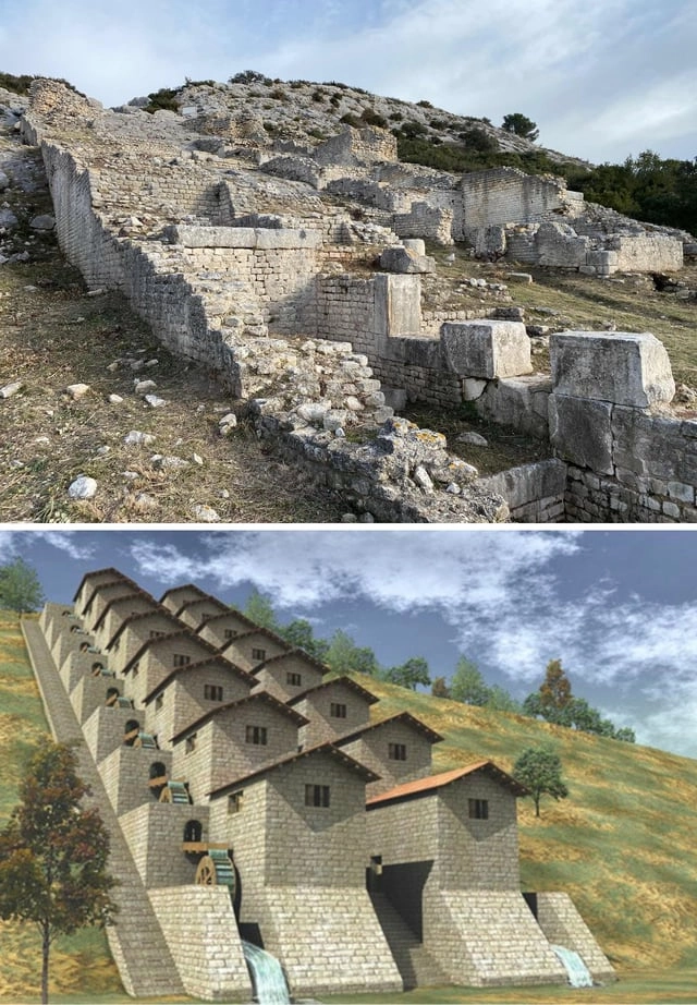
The Romans were expert hydraulic engineers, creating mill systems across the Empire. The most famous example was the Barbegal Complex in southern Gaul, a true factory of waterpower for so-called gang mills where multiple wheels worked in tandem for mass flour production.
While there is no evidence for such a large installation on the Coquet, the repeated siting of mills here, century after century, implies that the potential was first recognised in antiquity.
In this light, Guyzance and the reaches of the Coquet may have functioned as an industrial node within the Coquet Corridor, providing the Empire with its much needed corn.
Weldon Bridge: The Causeway Junction
At Weldon Bridge, the Coquet meets the line of the Devil’s Causeway, the principal Roman road running north from Corbridge, diagonally across Northumberland to the Tweed at Berwick and the ford there at the estuary.
The modern bridge sits on a later route half a mile to the east of the Roman road crossing point. At this ancient crossing point, the Coquet Corridor could plug directly into the frontier road grid, funnelling supplies from the coast to northern forts, and in reverse, grain milled to corn in the form of tax from the fertile farmland between the Muckle Cheviot and the sea.
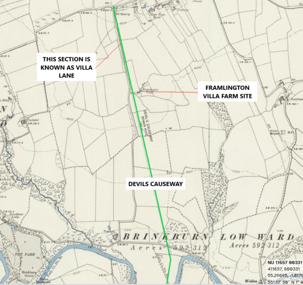
Lacking any archaeological evidence of a Roman road between the Devils Causeway and the port at Warkworth one must assume that goods were moved by water to meet the Roman road north and south, there is also the tantalising name ‘Villa Road’ here.
Longframlington and its Villa
If we look on maps of the area, the road that runs south from the western end of Longframlington is called Villa Road. It follows a section of the Devils Causeway that emerges from the Coquet at this point.
Why is it named thus? Is there a Roman villa buried somewhere here just waiting to be discovered? Is it similar to the Roman villa in Tossa-De-Mar in Spain, a place where a residential home was extended to incorporate an industrial area and dock by the sea?
I hasten to add there has been no such archaeological evidence found, so maybe it was on the lower end of the road near the water and has been gradually eroded by the meanderings of the river just like the north west corner of Habitancum (Risingham) fort.
Once again, the continuation of use and names, echoing down the centuries leave tantalising and frustrating hints of what may have been.
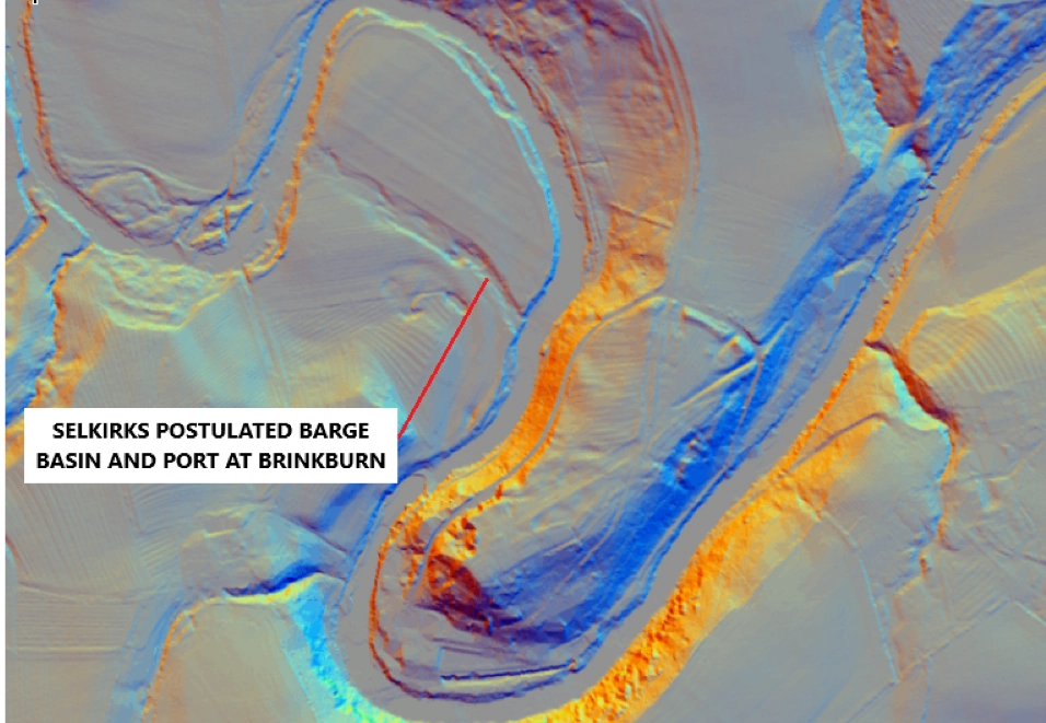
Brinkburn and Selkirk’s Barge Basin
The author and historian Raymond Selkirk argued that Roman engineers exploited rivers more intensively than is usually acknowledged. He postulated a Roman barge basin at Brinkburn, far upriver, where vessels could unload supplies.
Even if one does not accept all of Selkirk’s reconstructions, the broad meadows and gentle gradients of the Coquet support the plausibility of inland navigation at least to Brinkburn. This would make the Coquet a genuine arterial supply line, not a marginal stream. The movement of goods by water, as far as possible upriver, made the transport of heavy goods infinitely easier. We know large boats would be restricted in the shallow water of the rivers, but even relatively large items could easily be moved by one man on something as equivalently small as a kayak.
Interestingly, when Selkirk made his postulations in his book On The Trail Of The Legions in 1985, LiDAR imagery was not available. We can now see, on the image below, why he thought this. There is a clearly defined, man made channel across the meander of the river here.
The Coquet Roman Complex
When the evidence is assembled, a structured system emerges:
- Gloster Hill (Amble): cavalry altar, salt pans, training ground.
- Warkworth: fort on the neck, port in the river loop, cult cave nearby.
- Coquet Island: offshore signal and naval station.
- Guyzance: industrial milling centre with long continuity of use.
- Weldon Bridge: junction with the Devil’s Causeway
- Longframlington (Villa Road): villa estate controlling ridge farmland.
- Brinkburn: Selkirk’s inland port/barge basin.
All linked by one thing, the eternal river, wending its way inexorably to the sea as it has done since the end of the last ice age, mother nature’s highway.
This is no scatter of chance finds. It is a coordinated coastal and riverine complex, serving military logistics and anchoring Roman influence deep in the Coquet Valley.
Conclusion
The Coquet Valley has been overlooked in Roman studies, dismissed as peripheral to the Wall system. Yet the cumulative evidence suggests otherwise.
From altar to toponym, from mill to harbour, from villa to barge basin, the Coquet may have functioned as a hidden artery of supply, feeding troops and embedding Roman presence in a landscape still marked by their choices.
If even part of this model proves correct, the Coquet Corridor represents a missing chapter in the story of Rome in the North.
With love from The Crasterfarian XX
Some fascinating thoughts there.
Gloster Hill and the altar have always fascinated me, but the lack of material evidence, even if only rubbish, seems to rule out a settlement.
The thought that the altar may have been set up at a cavalry parade ground, which could easily have been a small distance away from a fort, does allow for a lack of material evidence. And if the fort was at Warkworth, I think that is plausible, but again leaves the question of material evidence. The building of the castle could easily have obliterated any sign of a fort, but somewhere there must be broken pottery, middens etc – rabbit burrows & mole hills look out!
The other thought which occurs to me, and which would go some way to explain the lack of material evidence, is that this infrastructure, if it existed, may only have existed for a short period within the Roman period, given the to and fro and changing situation north of the wall.
Interesting thoughts, thanks.
Btw, is that a promontory fort showing up on the lidar opposite the postulated barge port at Brinckburn?
Dave
It’s worth mentioning a few more things.
Samian-ware and the odd coin found at the loop of the Coquet at the bottom of Warkworth village.
The Roman camp who’s groundwork are still visible under the Running Fox and on the periphery at longframlington, just off the devils causeway, marked on ordinance survey.
On archi.uk, roman theorised cropmarks on the burn loop at the base of Gloster Hill as well areas nr Guyzance with field names such as ‘low camp’ and roman theorised groundworks nr Hazon.
All adds to the strong theorised presence of small camp areas along the Coquet and Romano-British farmland in the area.
Cheers, I wasn’t aware of the material evidence from Warkworth, certainly adds to the case.
Dave
Also, yes that is a promontory fort above the medieval brinkburn priory complex.
Many years ago I recall that a sizeable number of coins were discovered at Gloster Hill Amble when the land was being prepared for new housing. As a surveyor I was required to visit the site the next day and learnt about this find. I have often wondered what happened to those coins and thought that they might be on display at your museum. As to when this was, I think it would probably be during the 1980’s. I would be interested to know so that my wife and I can visit. Kind Regards, Brian Friend (Alnwick)
Hi Brian, I can’t find any record of this find online.