By Crasterfarian
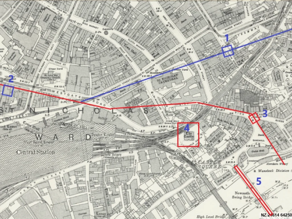
During various excavations of Hadrian’s Wall, it was assumed, due to dead reckoning of distance between milecastles, that Milecastle 4 was sited where Pilgrim Street crosses the route of Hadrian’s Wall in Newcastle City Centre (map point:1). This theory was initially based on rubble remains uncovered during construction work on Pilgrim Street.
However, the following theory challenges that initial identification, proposing instead that these remains are part of a reused gateway built into the extension of Hadrian’s Wall to Segedunum. Moreover, why would the Romans build Milecastle 4 so close to the fort?
This extension of the Wall (blue line) was made after the main building of the Wall (red line) was completed in the west, It is thought this extension to the east was built from 126-128AD.
The extension would have been essential for protecting the land to the north and east against raiding parties coming down the Ouseburn Valley. There would certainly have been a civilian vicus in this area.
Such a gate would have facilitated controlled movement up from the bridge (map point:5), a key military route up into the tribal lands of the Brigantes and the Votadini. Before the bridge was constructed, the nearest fordable point of the Tyne was at Newburn several miles up stream.
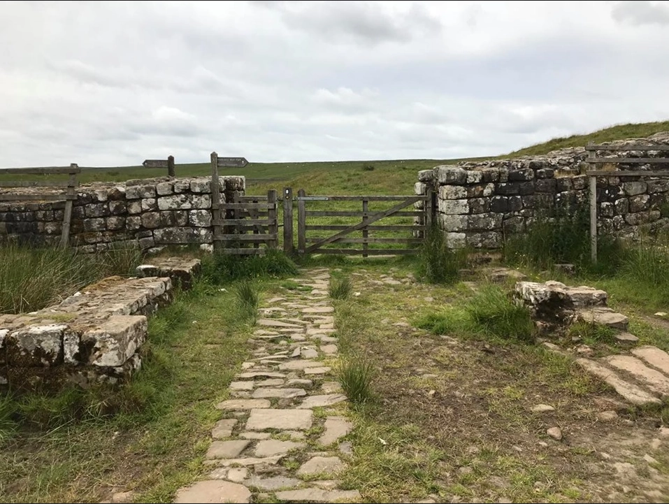
The gate would have been similar in construction to the gates at both the Knag Burn (See image below) near Vercovicium (Housesteads) and the Port Gate that allowed Dere St through the wall to the north of Corstopitum (Corbridge).
There was also a Port Gate in medieval Newcastle, located in the Town Wall at the northern end of Pilgrim Street, near today’s junction with Blackett Street and Northumberland Street.
Beneath this area, archaeologists have found evidence of a Roman road, likely connected to Hadrian’s Wall leading to/from Pons Aelius. Its route aligns with modern Pilgrim Street.
The meandering lower reaches of Pilgrim Street provided a direct but manageable gradient up from the bridge toward the Roman gate in the Wall.
Pons Aelius fort was built around 120AD to defend the northen side of the bridge, and was probably initially a marching camp to protect the bridge builders from attack. The fort stood alone on the promontory directly beneath where the Castle Keep has been situated for the last 900 years.
When the Wall’s construction started in 122AD it began at Pons Aelius and headed west.
As the site was a stand-alone fort it’s unlikely that the Romans would have incorporated the fort into the Wall’s construction, particularly as the original plan for the Wall was not to include forts. This also happened at both Camboglanna (Castlesteads) and Magnis (Carvoran)—forts both detached from the wall, Magnis being constructed during the time of Agricola.
The most obvious route for an early section of Hadrian’s Wall to protect the bridge would have been down to the riverside (marked in red) via the route of the Side, providing a curtain wall to protect the north and eastern approaches to the bridge. It may have even reached out into the Tyne and provided mooring, just like the latter spur at Segedunum. Who knows, this may have been the original location of the fabled statue of Hadrian, depicted as Neptune…
This initial curtain wall would need a gate too (map point:3), maybe somewhere adjacent to the current Akenside Pub to allow bridge traffic north. This gate may have been dismantled and moved to location 1 during the extension phase of work.
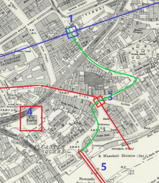
The road, marked in Green, winding up past All Saints Church, bends around to reduce the gradient, a typically Roman engineering solution for road construction up steep valley sides.
This route and gate would also negate the need for bridge traffic to pass through the fort for collection of taxes or bridge tolls, as the climb to the fort from the bridge would have been impossible for carts.
The retaining wall that today supports the ground to the south of All Saints looks to contain a centre section of cut stones that appear distinctly Roman (See Google Earth image).
This section of modern road was likely Roman in origin.
All Saint’s Church is believed to be built on top of or near the site of a Roman temple or temple complex, repurposed to Christianity through continuation of use, similar to many other sites deemed pagan, in particular, Mithraic temples. Its modern name of Pilgrim Street would also suggest that.
The nearby Pandon Street may derive from ‘Pantheon’—the Roman term for a temple to all gods. Such linguistic continuity supports the argument for earlier Roman religious presence on the site.

Conclusion
This theory reframes the eastern end of Hadrian’s Wall as more dynamic than traditionally presented. The extension between Pons Aelius and Segedunum was a necessary strategic adaptation, and we must expect there to be remains buried so deep, or removed during later construction projects, that some theories can never be proven.