Or watch the video here:
Or watch this 22 minute talk at the Newcaslte Society of Antiquaries showcase:
Never miss an article. Enter your email or give our FB page a like

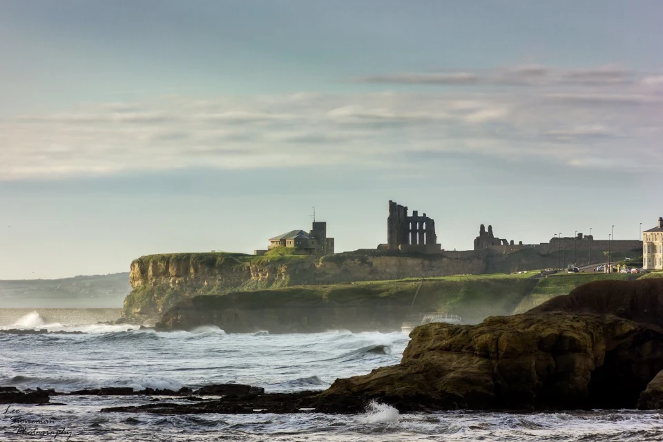
No air-built castles, and no fairy bowers,
But thou, fair Tynemouth, and thy well-known towers,
Now bid th’ historic muse explore the maze
Of long past years, and tales of other days.
Pride of Northumbria!—from thy crowded port,
Where Europe’s brave commercial sons resort,
Her boasted mines send forth their sable stores,
To buy the varied wealth of distant shores.
Here the tall lighthouse, bold in spiral height,
Glads with its welcome beam the seaman’s sight.
Here, too, the firm redoubt, the rampart’s length,
The death-fraught cannon, and the bastion’s strength,
Hang frowning o’er the briny deep below,
To guard the coast against th’ invading foe.
Here health salubrious spreads her balmy wings,
And woos the sufferer to her saline springs;
And, here the antiquarian strays around
The ruin’d abbey, and its sacred ground.
Jane Harvey
From ‘The Castle of Tynemouth. A Tale’ (1806)
Photograph: Lee Stoneman
Photograph: Lee Stoneman
No air-built castles, and no fairy bowers,
But thou, fair Tynemouth, and thy well-known towers,
Now bid th’ historic muse explore the maze
Of long past years, and tales of other days.
Pride of Northumbria!—from thy crowded port,
Where Europe’s brave commercial sons resort,
Her boasted mines send forth their sable stores,
To buy the varied wealth of distant shores.
Here the tall lighthouse, bold in spiral height,
Glads with its welcome beam the seaman’s sight.
Here, too, the firm redoubt, the rampart’s length,
The death-fraught cannon, and the bastion’s strength,
Hang frowning o’er the briny deep below,
To guard the coast against th’ invading foe.
Here health salubrious spreads her balmy wings,
And woos the sufferer to her saline springs;
And, here the antiquarian strays around
The ruin’d abbey, and its sacred ground.
Jane Harvey
From ‘The Castle of Tynemouth. A Tale’ (1806)
Where is the book available for purchase please.
I haven’t printed copies of this yet, but all digital content on here is free.
A follow up post to this paper regarding a discovery at the site https://penbal.uk/possible-mosaic-found-at-blake-chesters-in-1970s-and-80s/
I am loving your work and site. Thank you so very much.
I began working with an amateur archaeologist from Walbottle that dug at sites such as Arbeia, and is something of a Celtic expert. We used to use psychic impressions and then research them to see if they were evidenced.
I digress, your description of Blake Chesters (between my great grandad’s house at Hylton Terrace and my childhood GP’s practise on Railway Terrace), is quite in accord with what I mentally viewed – and we both agreed – as the end of the ‘wall’. Not a wall, as such, but an encampment along a ridge in a line towards the Priory castle from Wallsend. A place where we encountered the ghost of a monk, who rushed us near the gate.
I’ve lived on Trevor Tce. for decades, and once had the strong vision of this land, as a green site with Romanesque tents – and at first thought this too was a Roman encampment. Later I would discover it to have been the old cricket grounds and site of the fayre. That made sense of what I saw.
Like you, some of my family – the Heeney’s, came across in the 1800s and stayed occupying Low Town, settling in Preston village. We discovered that one of my ancestors is an aunty of Danny Lawrence. We’ve been friends ever since. My family have included early migrants to Shields from Galashiels in late 1700s – the Frasers – and my grandfather who was a polis for 26 years on the Tynemouth Force.
(I wonder if you know anything of the buried mustard gas near Billy Mill – something I’ve never heard mentioned, but he told me as a child? As a soldier for 13 years prior to that, he told me many things of interest, and I kick myself for never having documented any of his tales.)
Too much to say – my enthusiasm gets the better of me.
Thanks again. Amazing work, well done.
Ivan
Thank you for this reply, Ivan. Much appreciated.
So if you factor in the ideal positioning of this site as Blake Chesters, with the plentiful supply of springs before and behind (Spring near Spring Gardens, Ridge cottage well and reservoir etc. etc. – the Waterville/Meadow Well links etc. etc. the stream of Hylton Street etc.) being both practical and strategic for a camp that can defend its water even if besieged from the front, I think this adds weight to your case.
Cheers
Ivan