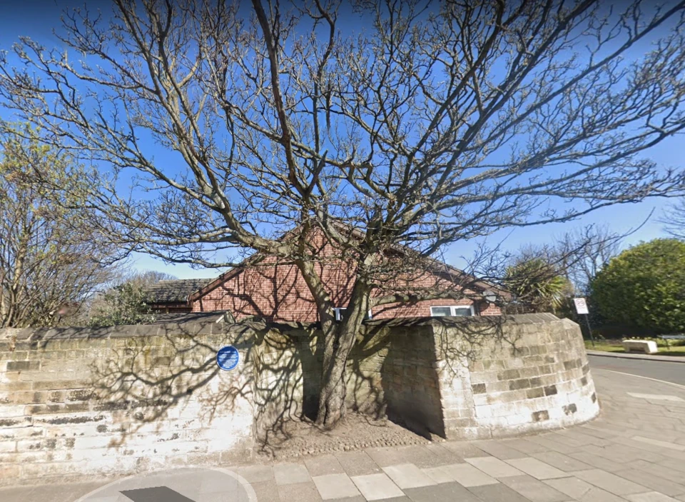
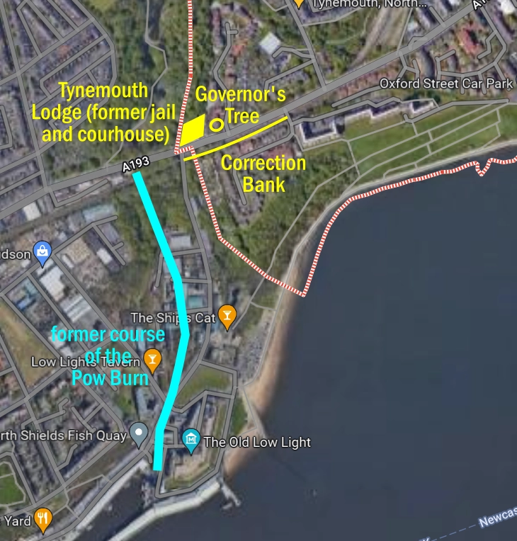
The Governor’s Tree is a familiar Tynemouth fixture that sits in a recess in the wall towards the bottom of Correction Bank—the stretch of Tynemouth Road between the Mariners’ Asylum and the Tynemouth Lodge. Interestingly, the Lodge is next door to the remains of a courthouse and jail that existed during the 18th and 19th centuries, hence the name, Correction Bank. The bank leads to the large road and railway embankment which culverts the Pow Burn and envelops Northumberland Park, creating Tynemouth’s cordon sanitaire.

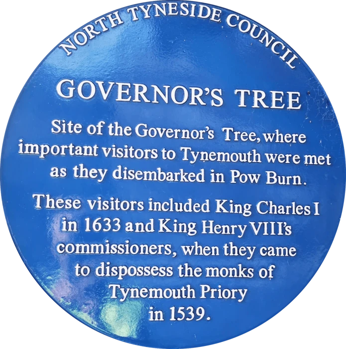
The Governor’s Tree is honoured with a blue plaque which asserts.
For a while this copy caused some controversy, making the national press because of an error in the date, which was corrected. However, this is not why I find the plaque controversial.
It seems to me that it’s unmerited. Not only is the tree and the wall around it likely no more than 100 years old, but there is, as far as I know, no evidence of a historic tree. Folklore and anecdote are great, but the vague text on the plate is not enough for a blue plaque.
I’d love to be corrected on this, but even the entry in the bible which is the Tyne & Wear Historic Environmental Record, shows no evidence either. Strangely for T&W HER, the page offers only what is stated on the plaque and a link to the Mail article. This implies that the entry was made after the plaque made the news in 2014.
Update: It appears the only reference available is from William Garson in his paphlet: A Ramble in Tynemouth and Cullercoats, written in 1924:
“King Charles I was a visitor on three occasions during his troublous reign. The first visit was on June 5, 1633, whilst on his way to Scotland to be crowned. He was conveyed by the master and brethren of Trinity House in their barges to the Governor Tree at Pow Burn, being received by the Commander of Tynemouth Castle.”
Garson, though a skilled and stylistic writer was not know for his scrupulousness as a historian and no further detail is provided.
Local Nuance Needed
I’m not claiming there wasn’t a boundary tree and I’m not even saying it wasn’t graced with the presence of a fugitive Charles I or Henry VIII’s bailiffs. But there’s no evidence that it was.
I believe the tree is the site of an old turnpike and entry point to Tynemouth, roughly mirroring the 8-mile stone on the other side of the Pow Dene. This milestone sits behind the railing in Northumberland Park and, like the Governor’s Tree, may have a much older precedent, possibly Roman in origin and possibly connected with the site called ‘Adrian’s Mound’ that was uncovered there.
It is also worth noting that the current tree, standing several hundred yards east of the course of the Pow Burn, does stand at pretty much the official border between Tynemouth and Shields, while the very earliest 13th century settlements in Shields, on the east bank of the Pow Burn gut also fall just outside this boundary line.

Fact can be stranger than fiction
The site of the Governor’s Tree, I believe, rather than just being a Tudor-era embarkation point, was an older boundary marker showing the extent of the Prior’s lands, mirroring the Monkstone on the equally ancient north-south axis into Tynemouth that is now the Broadway.
Beyond these portentuous points, fugitives could no longer claim asylum by virtue of being on church land.
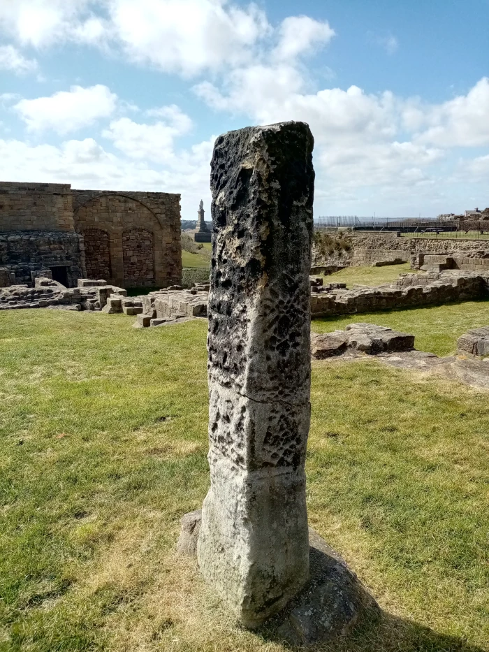
The Saxon cross known as the Monk Stone stood beside a gallows. The 1320 Tynemouth Chartulary sourced and discussed in depth here, refers to the prior’s gallows at the Monk Stone and The Monthly Chronicle of North Country Lore and Legend, (August 1887 p255), goes into detail regarding the function of this and similar guideposts to medieval pilgrims and refugees.
This is what Craster in History of Northumberland (1907) had to say on the matter:
“The right of sanctuary was another important privilege possessed by the priory from an early date. Tynemouth had its grith or special peace, of which the boundaries, marked by crosses where roads intersected them, probably extended a mile around the priory,* and it is not impossible that the Monk’s Stone near the junction of the roads leading from Tynemouth to Whitley and to Monkseaton, is a memorial cross removed from the Anglian cemetery to serve in post-Conquest times as a grith cross. Suspected or convicted felons who crossed the bounds of the grith escaped the penalties of life and limb. To these the prior gave his protection, as in the case of Thomas de Carliol, for whom the mayor and good men of Newcastle asked permission to live in his hired house at Tynemouth, as he had been guilty of an assault.” A lawless population of grith-men grew up within the limits of sanctuary, whose services were occasionally useful in Scottish wars. In 1342 Edward Baliol was empowered to array the grith-men of Tynemouth and other northern sanctuaries, if they were willing to serve at their own expense upon a pardon being granted to them.’ Occasionally prisoners in Newcastle succeeded in breaking prison and found a safe asylum at Tynemouth, their escape, on at least one occasion, being attributed to the miraculous agency of St. Oswin.”
*As in the case of Hexham,
A History of Northumberland, Volume VIII, The Parish of Tynemouth, HHE Craster, (1907) p211-212
Similarly, the Governor’s Tree, lying not quite a mile from the Priory, but at a natural boundary and a place long associated with criminal justice, could well have been, at one point or another, a place of execution. Such a gibbet would’ve served as a clear warning on the road into Tynemouth to would-be villains and highwaymen.
The title of ‘governor’, which must be presumed given the text of the plaque, to refer to the governor of Tynemouth Castle, who originally obtained power at the expense of the prior during the Dissolution of the Monasteries, could actually be a more modern appellation referring to the governor of the House of Correction.
Before 1539, the prior of Tynemouth had his own court and justices, with a jail, a pillory and gallows. He also owned the right to all treasure from sea wrecks and the property of all felons and murderers, as well as enjoying freedom from taxes, tolls and customs, and most of the rights to coal mining in the area. But post-Dissolution, this was all flipped and the legal duties in the manor fell to the common law courts and assizes, empowered in the early days, by the edicts of the Star Chamber in London—the king’s own law court.
In times since then, the prison governor, based at Correction Bank, would have overseen discipline and meted out the occasional execution at the site—rare events that would have drawn spectators from all around. This grim association would, over time, have given way to today’s more sanitised narrative of the tree’s significance.
It’s just a thought and a theory. I don’t know if there’s always been a tree there. Does anyone know for sure? But I do think there’s been a boundary marker, perhaps a tree, since medieval times and as stated, I’d love to see some evidence to justify the plaque.
Listen to the audio for this post here:
Never miss an article. Enter your email or give our FB page a like


No air-built castles, and no fairy bowers,
But thou, fair Tynemouth, and thy well-known towers,
Now bid th’ historic muse explore the maze
Of long past years, and tales of other days.
Pride of Northumbria!—from thy crowded port,
Where Europe’s brave commercial sons resort,
Her boasted mines send forth their sable stores,
To buy the varied wealth of distant shores.
Here the tall lighthouse, bold in spiral height,
Glads with its welcome beam the seaman’s sight.
Here, too, the firm redoubt, the rampart’s length,
The death-fraught cannon, and the bastion’s strength,
Hang frowning o’er the briny deep below,
To guard the coast against th’ invading foe.
Here health salubrious spreads her balmy wings,
And woos the sufferer to her saline springs;
And, here the antiquarian strays around
The ruin’d abbey, and its sacred ground.
Jane Harvey
From ‘The Castle of Tynemouth. A Tale’ (1806)
Photograph: Lee Stoneman
Photograph: Lee Stoneman
No air-built castles, and no fairy bowers,
But thou, fair Tynemouth, and thy well-known towers,
Now bid th’ historic muse explore the maze
Of long past years, and tales of other days.
Pride of Northumbria!—from thy crowded port,
Where Europe’s brave commercial sons resort,
Her boasted mines send forth their sable stores,
To buy the varied wealth of distant shores.
Here the tall lighthouse, bold in spiral height,
Glads with its welcome beam the seaman’s sight.
Here, too, the firm redoubt, the rampart’s length,
The death-fraught cannon, and the bastion’s strength,
Hang frowning o’er the briny deep below,
To guard the coast against th’ invading foe.
Here health salubrious spreads her balmy wings,
And woos the sufferer to her saline springs;
And, here the antiquarian strays around
The ruin’d abbey, and its sacred ground.
Jane Harvey
From ‘The Castle of Tynemouth. A Tale’ (1806)
Interesting article – i’d like to learn of any facts or early references to this tree also. Thanks.