This following text is from a post on a Tynemouth History Facebook group on a topic that has been sitting fragmented in my mind for some time. The commments and discussion, though relevant and extremely enlightening, are far too numerous to summarise here.

The surprising thing was that once I posted this basic theory of the water courses and springs that run through and below Tynemouth, several new (old) wells in the village came to light, providing what developed into a fairly extensive map of the hydrological features of the village. My conjectures are by no means authoritative or academically rigorous, but I think this post does provide a basis for a further survey of Tynemouth’s wells and further appreciation of what has always been here beneath us.
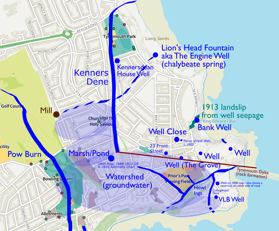
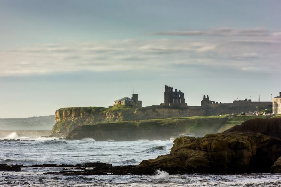
“One thing many don’t realise about Tynemouth is that it has a very high water table. And I often wonder what the landscape was like before the village was really settled. The few maps there are tell you little.
Basically, everything south of Front Street and Manor Road on the incline towards the ‘Howl Ings’ (Priors Dene) was boggy and the gully that leads to the walkway onto the Pier would have been the outlet for water coming ultimately from the Pow Burn in Spital Dene, when that was an actual waterway.
The flow would have started, I’m guessing, near where the mill was at the top of Edith Street and Dene Road and would have carried on to where the station is and flooded that area and saturated the land beyond there all the way to the Haven.

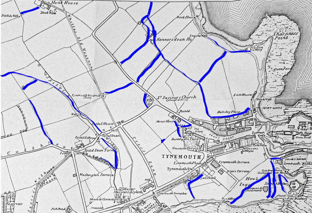
I also believe that a burn forked the other way from Holy Saviours and the top of the Station bank down to the Longsands, ending at the spring where the Lion Head Fountain lays beneath the sand, as well as down ‘Kenners Dene’ to flow out at the bottom of Beach Road, because the gully down to the seafront there also points to a water course. And there is also the spring at the top of the Longsands below Beaconsfield and we know the playing fields on Links Road had a large storm drain put in a few years ago. So there’s water flowing all the way down through Tynemouth.
That leaves the village as a sort of island from the Three Corner Field all the way to the south side of Front Street. Within that area there is Well Close, so the main well for the village must have been there? And the Castle grounds has two wells (although I’m not sure if one or both of them are in fact ventilation for something more recent). But at one time they must have been functioning wells as Penbal Crag is also heavily waterlogged.”
Historical Observations
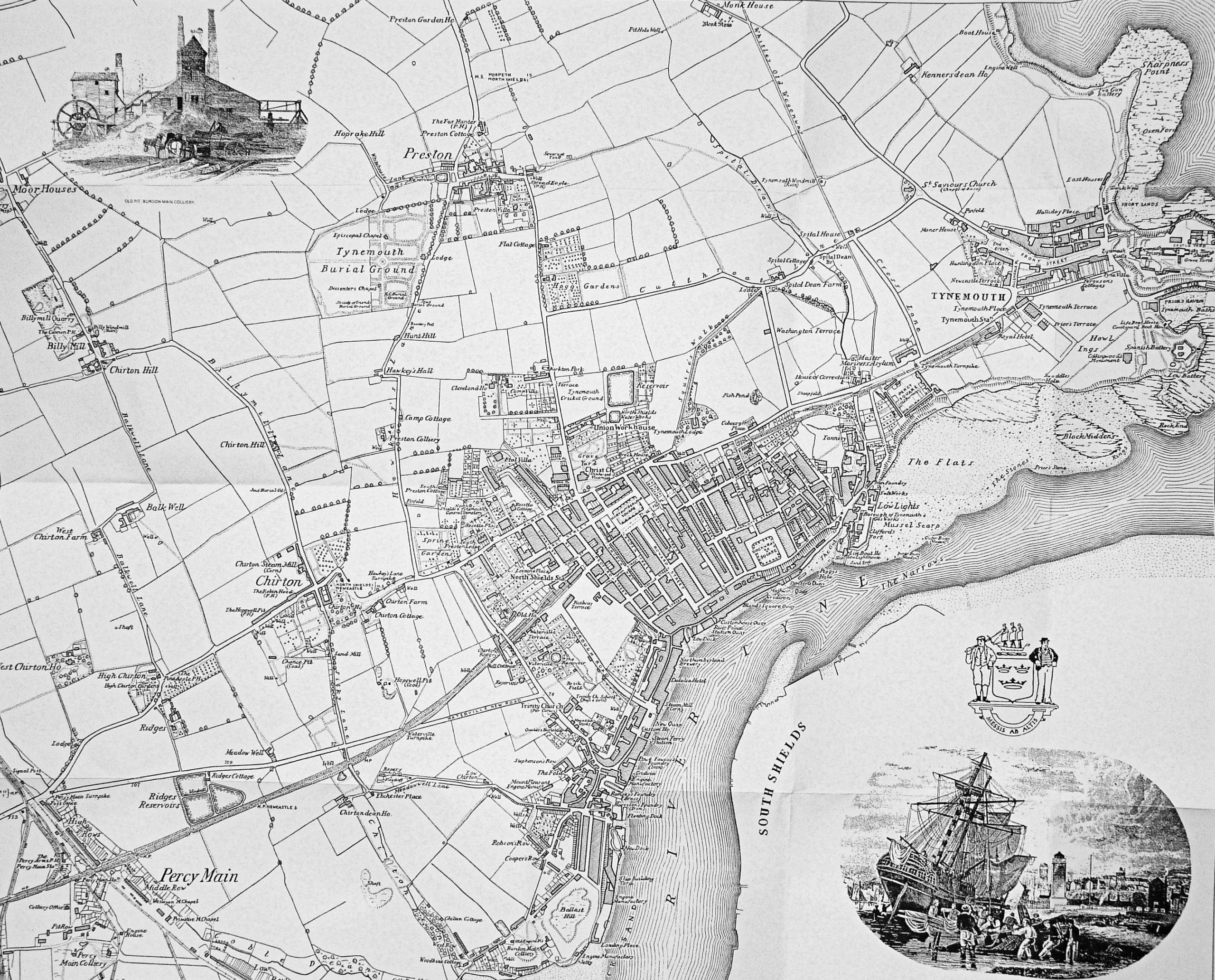
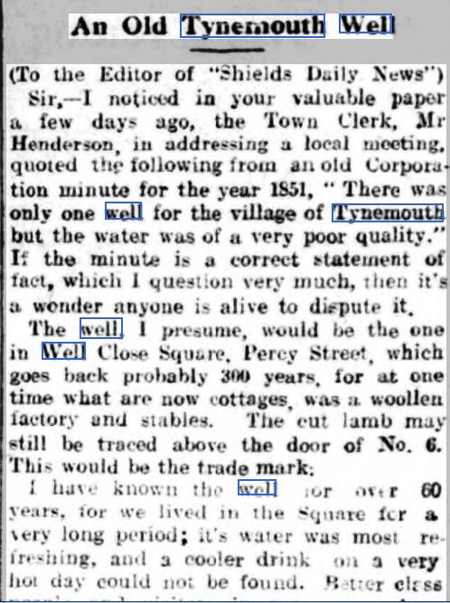
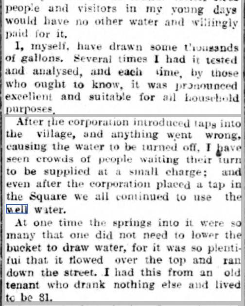
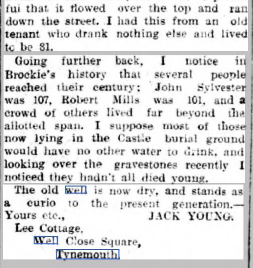
The nature of the water supply: “In rural areas the supply was even worse supplied, than the town (of North Shields) district of the Borough. Tynemouth possessed several private wells but the water was of very bad quality, hard, occasionally brackish and very often producing diarrhoea in persons unaccustomed to its use and sometimes to its residents as well. It was often remarked that horses got out of condition in Tynemouth and the cause was undoubtedly the bad water. There was only one public well in the Village, it was twenty-eight feet deep. Some older people had stated that it was once nearly full, afterwards it stood at eight, then at five and now in 1851 it was only three feet deep. It was so bad in quality that it was unfit either for cooking or washing with, but it was the only water that could be obtained”.
Deficiency of the drainage: “Beyond the limits of the Improvement Act, there was no superintendence whatsoever. The township of Tynemouth for instance, with 250 houses had no system of street cleansing at all. It was under the Surveyors of the Highways and cleaned only once a week or once a fortnight; during the periods in between all the refuse lay on the streets. There was no dereliction of duty on the part of the Surveyors, for it was not their business to clean the streets”.
William Ranger report for the Board of Health, 1851 (a preliminary enquiry into the sewerage, drainage and supply of water, and the sanitary condition of the inhabitants of the Borough of Tynemouth).
In the following year new pipes were laid to bring fresh water from the North Shields Water Company.

Never miss an article. Enter your email or give our FB page a like
No air-built castles, and no fairy bowers,
But thou, fair Tynemouth, and thy well-known towers,
Now bid th’ historic muse explore the maze
Of long past years, and tales of other days.
Pride of Northumbria!—from thy crowded port,
Where Europe’s brave commercial sons resort,
Her boasted mines send forth their sable stores,
To buy the varied wealth of distant shores.
Here the tall lighthouse, bold in spiral height,
Glads with its welcome beam the seaman’s sight.
Here, too, the firm redoubt, the rampart’s length,
The death-fraught cannon, and the bastion’s strength,
Hang frowning o’er the briny deep below,
To guard the coast against th’ invading foe.
Here health salubrious spreads her balmy wings,
And woos the sufferer to her saline springs;
And, here the antiquarian strays around
The ruin’d abbey, and its sacred ground.
Jane Harvey
From ‘The Castle of Tynemouth. A Tale’ (1806)
Photograph: Lee Stoneman
Photograph: Lee Stoneman
No air-built castles, and no fairy bowers,
But thou, fair Tynemouth, and thy well-known towers,
Now bid th’ historic muse explore the maze
Of long past years, and tales of other days.
Pride of Northumbria!—from thy crowded port,
Where Europe’s brave commercial sons resort,
Her boasted mines send forth their sable stores,
To buy the varied wealth of distant shores.
Here the tall lighthouse, bold in spiral height,
Glads with its welcome beam the seaman’s sight.
Here, too, the firm redoubt, the rampart’s length,
The death-fraught cannon, and the bastion’s strength,
Hang frowning o’er the briny deep below,
To guard the coast against th’ invading foe.
Here health salubrious spreads her balmy wings,
And woos the sufferer to her saline springs;
And, here the antiquarian strays around
The ruin’d abbey, and its sacred ground.
Jane Harvey
From ‘The Castle of Tynemouth. A Tale’ (1806)
Hi, I was born in Tynemouth but now live in Canada. My roots remain in Tynemouth however and I have tons of books on the local area, still feel like I belong. Just watching Penbal on YouTube and thought you might have some info on this…
Spanish armada beaten by the British in the English Channel were blocked from returning to Spain. So, once ly option was to sail all the way round Britain , down the West coast of Scotland/Ireland and back to Spain. On the way up and around Britain, they stopped off for supplies, food, water. Some probably stayed put. So, the ‘Spanish Battery’ and ‘Spanish City’ get their name from these encampment
But, there’s little information in this period. Do you know any more?
Love the channel, keep it up.
I have another for you about light bulbs. Another time.
Geoff Wall
Hi Geoff, I believe the Spanish Battery is named after the mercenary troops of Julian Romero, who was stationed in Northumberland at the time of Henry VIII https://en.wikipedia.org/wiki/Juli%C3%A1n_Romero
Great stuff.
Are you aware that if you take a straight line through the Tynemouth wells on your map and extend it westwards, it runs through the Park, on an incline, where there are 2 or 3 natural springs that have dried over the years.
One is a project in the middle of the park partly worked on by my wife to create a small wildlife area in the remaining boggy area. This used to be an old pond with a stone surround.
Keep going west and you have the other spring at the dene at the west end of the park next to the bowling green. Now dried up, and was until recently artificially watered, but presumably is the outlet from the runoff flowing east and downwards into the Pow Burn (as well as the main one from the north west – Preston/Marden area. In fact, there is another little spring just south of the dene one hidden in the trees, where water rises to the surface, on the west side and above the main pond.
Keep going and you will have the Brock Farm reservoir to your left, all the way up my street, Trevor Terrace.
This street is fairly well known for the underground stream, which makes the houses here very damp. I’ve been in a couple and they were really musty. And having seen the state of the mini pond under my floor boards (despite the damp proofing), it’s clear that the underground stream runs beneath Trevor all the way down through the park into the Pow Burn.
No doubt the stream came down from the Preston pit and from Billy Mill as runoff too, and perhaps mingled with the subterranean watercourse. It’s all downhill from there until it hits the Pow Burn.
Perhaps another avenue for you to look at if you get into the various wells, natural springs and streams etc., especially as these will be areas of early human settlements.
All the best
Ivan
This is fascinating. I’m going to try and pinpoint all of these. Also, Bedford Street was the site of a stream called the Sikket Burn whih pooled into Dogger Letch, where the Haddock Shop dock is.
That line I speak of also corresponds with Shipley Road, forgot to mention it.
My wife’s very familiar with the park as part of the wildlife group, and if you want to see the springs, she’s happy to show you – the one on the west side of the pond buried in the trees is difficult to find. (She had an art project on that site called ‘the wisdom portal’ which you can see on @shonafraserart on Instagram if you’re interested)
Speaking of reservoirs, and may link to the Spring Gardens name, which links to your ‘Hadrian’s Wall’ site near Alexander Park, wasn’t the Hawkey’s Lane pool once a salt water reservoir – I don’t recall if it was once a natural reservoir though, or a repository for the Chirton end for public use (sea water?)? Just a speculation.
My mam used to swim there, and my grandad (the polis) used to teach people including the Police to swim there and the Tynemouth open air pool. (he once dived in the Tynemouth pool forgetting he had his helmet on, damaged his neck and could never turn his head fully around after that).
All the best
Ivan
I live two streets away from Shipley Rd. I know there was a pool there long ago and its on old OS maps, and water still collects outside the station after heavy rain.
We could speculate that the same downhill streams from Preston/Marden and the Billy Mill which crosses the golf course into the Pow Burn may have taken 3 – at least – separate tributaries.
The one straight down Trevor into the Pow Burn, meeting the Preston one, straight down to Bedford street.
Perhaps another from Billy Mill towards the Alexander Park Spring Gardens area roughly down Hawkey’s Lane.
The do rather correspond with old farms. Which makes sense, as early settlements, water sources and farms tend to go together. I also speculate that they may follow the coal seams too, and hence the proximity with old pits of early Shields
Utter speculation of course.
Cheers
Ivan
Hylton St, behind Waterville Road, which leads directly to Alexander Scott Park, seems to be an old watercourse as it still trickles with water. The Romans always built camps near streams.
“Corresponding with old farms” Yes, I think the Marden and Pow burns may have a common origin near two old farms called Burnt House and Seaton Ville seen on old OS maps.
Water pools in flat plains. It flows downhill. Coal seams on hills create springs.
Civilisation has always been guided by nature and access to water, so where you find water, you find the settlements, the farms etc.
I lived on Hartburn road Marden Estate for 5 years, incidentally 🙂 I assume the name derives from the actual burn. Of course, there are many other names that link with burns and wells in our area and on the outskirts – Cauldwell Lane, Redburn, Wellfield. Water runs downhill to the Tyne Valley and to the coast, so corresponding farmsteads and early settlements would mostly be concentrated in these locales. And that’s where the farms were too.
So there were also coal pits near the burns and streams and wells that we are talking about in Whitley/Hillheads/Foxhunters, as well as Hawkey’s and and Bedford street. Of course, we mined coal here very early on due to it being nearer the surface and accessible to those who settled here. And also had the water at the surface to use.
The surface/easiest to access resources were always the first mined and exploited. (There are theories linking old megalithic sites with exploitation of surface deposits such as gold, exploited by the likes of the Egyptians and Phoenicians etc. Which may have marked them as places of significance for the locals thereafter. Rarely mentioned in modern day discussions about these sites.)
Man was always first impressed by nature and resources, from the earliest times, which led to early myths, and later religions. Man has always settled and exploited the most convenient areas – access to water being the most essential element 🙂
The Romans always recognised that. Even defensively, assuring your water supply is essential. Any encampment that had a military purpose – such as Roman sites in our area – must have considered security of water sources.
If these local camps were positioned deliberately with easy access to water, in front and behind (as backup) then that makes perfect sense. Even if the main source was compromised by invaders taking up position to the fore, the sources behind down to the river would provide a necessary secondary resource. If indeed, the local camp was actually built for such a purpose; the main ‘action’ appears to be taking place further west at the time along the actual wall.
I’m sure there will be many more correlations to be found with confirmatory documentation. Understand the water and the geology and we can follow the clues in the evolution of the civilisations that developed as a consequence. Even if it only informs a theory, as a principle, helping us to know where to look for the clues, to hopefully find the evidence and proof.
All the best.
Ivan
What an excellent insight Ivan. Thank you.
Hello, sorry to resurrect this old threat! I’m reading all of your remarks with interest after spending a glorious week with my son in Longsands beach and reading about the Engine Well and the buried fountain. I’m reminded that a few years back we stayed in a property on Rosella Place, which had an artesian well in the back garden!
Old **thread**! (It’s late)