By Gary Holland
Christopher Saxton was arguably the most prominent cartographer working in England in his lifetime. Born in Dewsbury, Yorkshire, c1540, he is known for his detailed maps of the counties of England and Wales – a staggering body of work in any age.

During the Elizabethan age, map making became increasingly common, largely due to the availability of modern technology such as copper engraving and use of the printing press. Saxton’s survey of England and Wales, commissioned by Queen Elizabeth I, began in 1574, finishing in 1578. Once complete, his set of maps were first published in the Atlas of the Counties of England and Wales in 1579.
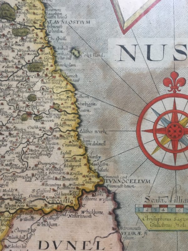
As with most documents, subsequent reprints were introduced. The map presented in this post is a slightly later design from 1637. For my particular locality, I have centred this post around the North Tyneside area which is within modern day county of Tyne & Wear and in particular the town of Tynemouth. The town of Tynemouth is historic; famous for it’s ruined Priory and Castle, but with a history reaching back to pre-Roman times.

The map, at around 400 years old, has some interesting place names. There are some which are easily recognisable to us today in Tyne & Wear – Munkseton, Blakworth, Whitlathe, Chirtons and on the south side Jerro and Sheales. However what’s also noted in big capital letters is TVNNOCELLVM– the old Roman name for Tynemouth. Or is it…..?
The Notitia Dignitatum, an incredible military document from the late-Roman period was created to list the various posts and forts of the Roman empire at the time. The document has a section regarding Britain where it lists many of the forts on Hadrian’s Wall among others and presents the particular unit which was assigned to a specific fort.
From this we know that the Tribunus Cohortis Primae Aeliae Classicae (First Cohort of the Aelian Fleet) were based at Tunnocellum. This location was, however, not listed in the equally historic Antonine Itinerary or Ptolemy’s Geographia, which may simply mean it was not a fort at those particular times.

In addition, the English antiquarian William Camden, writing of Tynemouth in his famous work Britannia, in 1587 mentions “……hoc Romanorum saeculo Tunnocellum fuisse fere asseverabo…..” translated roughly as “….I will almost say that this was Tunnocellum in Roman times…”
However, the truth is that the location of Tunnocellum is not certain due to lack of evidence – Roman inscriptions, for example. The location of the fort is now widely regarded by modern historians to be Ravenglass on the west coast of England in Cumbria, rather than the east as shown on this map. This is because three objects have been found at Ravenglass naming the First Cohort of the Aelian Fleet, and Ravenglass was a well established marine base to protect the coast from Irish pirates.
Nevertheless, there’s still a huge amount of undiscovered history beneath the Priory and it’s probable, certainly according to the great antiquaries, that there was a Roman presence on this multi-purpose site at Tynemouth: a temple, a villa, a garrison, a meeting place of some description? We can but speculate…
Never miss an article. Enter your email or give our FB page a like

I would find it odd that the world’s Greatest military Power that had a presence here for four hundred years never fortified pen ball crag , Likewise the idea of the Wall ending in lower Carville Wallsend is also militarily stupid and highly unlikely .I think a Fortification at Tynemouth and a continual Wall maybe not on the same scale as the great wall linked up to Segedunum ,via a fort on Coach lane shields and a smaller outpost at Chirton continuing to Howdon ,all guarding natural river crossing sites in existence to this day .
I agree Steve. Also, there’s never too much mentioned about the Spanish Battery either but that, in it’s own way, is just as an important place so potentially a site of some sort was there.
Great comment and insight Steven. I think rather than a continuation of the actual Wall, there was the “Fosse” being a natural ridge and rampart running more or less along where the Metro line is now, and several stations along that. Norham school looks a likely site, Blake Chesters on Coach Lane of course, and “Adrians Mound” at Northumbnerland Park, with this natural rampart terminating at Penbal Crag. Indeed, Tynemouth village is built on this fosse, also known in geological terms as the Tynemouth Dyke.
There’s also the site of Greenchesters in Howdon that needs further study.